
Osijek topographic map
Interactive map
Click on the map to display elevation.
About this map
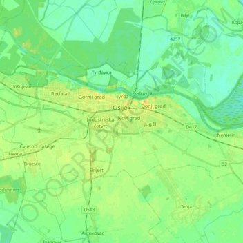
Name: Osijek topographic map, elevation, terrain.
Location: Osijek, Grad Osijek, Osijek-Baranja County, Croatia (45.51407 18.59620 45.58006 18.78136)
Average elevation: 285 ft
Minimum elevation: 256 ft
Maximum elevation: 331 ft
Osijek (Croatian pronunciation: [ôsijeːk] (listen)) is the fourth-largest city in Croatia, with a population of 96,848 in 2021.[1] It is the largest city and the economic and cultural centre of the eastern Croatian region of Slavonia, as well as the administrative centre of Osijek-Baranja County. Osijek is located on the right bank of the Drava River, 25 km (16 mi) upstream of its confluence with the Danube, at an elevation of 94 m (308 ft).
Other topographic maps
Click on a map to view its topography, its elevation and its terrain.
Trnava
Croatia > Osijek-Baranja County
Trnava, Općina Trnava, Osijek-Baranja County, 31411, Croatia
Average elevation: 449 ft