
Conover topographic map
Click on the map to display elevation.
About this map
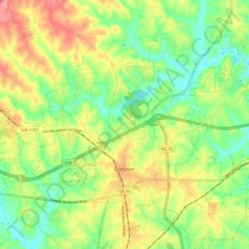
Name: Conover topographic map, elevation, terrain.
Average elevation: 974 ft
Minimum elevation: 843 ft
Maximum elevation: 1,145 ft
Catawba County trails, hiking, mountain biking, running and outdoor activities
Other topographic maps
Click on a map to view its topography, its elevation and its terrain.
Terrell
United States > North Carolina > Catawba County
Terrell is located at 35°35′20.72″N 80°58′39.5″W / 35.5890889°N 80.977639°W / 35.5890889; -80.977639 within area code 828, ZIP code 28682, and FIPS place code 67180. It sits at an elevation of 289 m (948 ft).
Average elevation: 810 ft
Hickory
United States > North Carolina > Catawba County > Hickory
Lake Hickory was named after the City of Hickory and runs along its northern edge. The lake covers almost 4,223 acres (17.09 km2) with 105 miles (169 km) of shoreline. Full pond elevation is 935 feet (285 m). Lake Hickory is a reliable source of water for the Cities of Hickory and Conover and the Town of Long…
Average elevation: 1,070 ft