
General Tinio topographic map
Click on the map to display elevation.
General Tinio
Farming is the livelihood of majority of the residents. Even though located at the foot of the Sierra Madre Mountain Ridges, the topography is generally plain ideal to agricultural products such as palay and vegetables. A number of poultry broiler contract growers are located in the municipality. Other industries include furniture and fixtures, backyard poultry, cattle and livestock, vegetable production and minor agricultural livelihoods like duck raising. "Ikmo" or betel leaves production is one dying symbol of the town. The practice of chewing betel leaves by the older generation was not adopted by the younger generation even though of its reported natural anti-cancer formula.
About this map
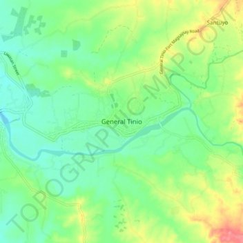
Name: General Tinio topographic map, elevation, terrain.
Location: General Tinio, Nueva Ecija, Central Luzon, 3104, Philippines (15.31013 121.00980 15.39013 121.08980)
Average elevation: 177 ft
Minimum elevation: 92 ft
Maximum elevation: 341 ft
Other topographic maps
Click on a map to view its topography, its elevation and its terrain.
Pampanga River
Its main tributaries are Peñaranda and the Coronel-Santor rivers on the eastern side of the basin and the Rio Chico River from the northwest side. The Angat River joins the Pampanga River at Calumpit, Bulacan via the Bagbag River. Mount Arayat (elevation: 1,026 metres (3,366 ft)) stands in the middle of the…
Average elevation: 623 ft
Pantabangan Dam
Philippines > Nueva Ecija > Pantabangan > Fatima
The dam is a 107 m (351 ft) tall and 1,615 m (5,299 ft) long embankment-type with 12,000,000 cu yd (9,174,658 m3) of homogeneous earth-fill and an impervious core. The crest of the dam is 12 m (39 ft) wide while the widest part of its base is 535 m (1,755 ft). The dam's crest sits at an elevation of 232 m (761…
Average elevation: 689 ft
Talavera
The municipality's terrain is relatively flat, with slope ranging from 0 to 3%. Due to the flat topography, the land is suited for agricultural, commercial or industrial development. It is bordered by Cabanatuan, Llanera, Muñoz, Aliaga, General Mamerto Natividad, Santo Domingo and San Jose.
Average elevation: 161 ft