
Thank you for supporting this site ❤️
Make a donation
Make a donation
Gear up for your next adventure:
As an Amazon Associate, this site earns from qualifying purchases at no extra cost to you.
Кез topographic map
Click on the map to display elevation.
Thank you for supporting this site ❤️
Make a donation
Make a donation
Gear up for your next adventure:
As an Amazon Associate, this site earns from qualifying purchases at no extra cost to you.
About this map
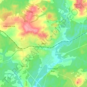
Name: Кез topographic map, elevation, terrain.
Location: Кез, Kezsky District, Udmurtia, Volga Federal District, Russia (57.85645 53.67392 57.93645 53.75392)
Average elevation: 646 ft
Minimum elevation: 545 ft
Maximum elevation: 837 ft
Thank you for supporting this site ❤️
Make a donation
Make a donation
Gear up for your next adventure:
As an Amazon Associate, this site earns from qualifying purchases at no extra cost to you.