
Lansing topographic map
Interactive map
Click on the map to display elevation.
About this map
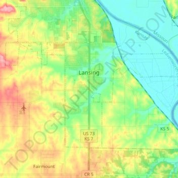
Name: Lansing topographic map, elevation, terrain.
Location: Lansing, Leavenworth County, Kansas, 66043, United States (39.20284 -94.96581 39.27422 -94.82651)
Average elevation: 873 ft
Minimum elevation: 738 ft
Maximum elevation: 1,106 ft
Other topographic maps
Click on a map to view its topography, its elevation and its terrain.
Maywood
United States > Kansas > Leavenworth County > Leavenworth
Maywood, Leavenworth, Leavenworth County, Kansas, 64092, United States
Average elevation: 807 ft
Fairmount
United States > Kansas > Leavenworth County
Fairmount, Leavenworth County, Kansas, United States
Average elevation: 951 ft
Leavenworth
United States > Kansas > Leavenworth County
Leavenworth, Leavenworth County, Kansas, United States
Average elevation: 879 ft
Linwood
United States > Kansas > Leavenworth County
Linwood, Leavenworth County, Kansas, United States
Average elevation: 814 ft
Hoge
United States > Kansas > Leavenworth County
Hoge, Leavenworth County, Kansas, United States
Average elevation: 906 ft
Basehor
United States > Kansas > Leavenworth County
Basehor, Leavenworth County, Kansas, 66007, United States
Average elevation: 938 ft
Fort Leavenworth
United States > Kansas > Leavenworth County > Leavenworth > Leavenworth
Fort Leavenworth, Leavenworth, Leavenworth County, Kansas, 66027, United States
Average elevation: 827 ft
Leavenworth
United States > Kansas > Leavenworth County > Leavenworth
Leavenworth, Leavenworth County, Kansas, 66048, United States
Average elevation: 909 ft