Geolocate

Basehor topographic map

Click on the map to display elevation.

About this map

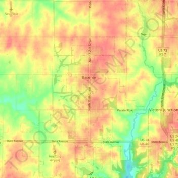
Name: Basehor topographic map, elevation, terrain.

Location: Basehor, Leavenworth County, Kansas, 66007, United States (39.10171 -94.97354 39.17237 -94.90056)

Average elevation: 938 ft

Minimum elevation: 820 ft

Maximum elevation: 1,010 ft

Leavenworth County trails, hiking, mountain biking, running and outdoor activities

Other topographic maps

Click on a map to view its topography, its elevation and its terrain.

Hoge

United States > Kansas > Leavenworth County

Average elevation: 906 ft

Maywood

United States > Kansas > Leavenworth County > Leavenworth

Average elevation: 807 ft

Fairmount

United States > Kansas > Leavenworth County

Average elevation: 951 ft

Gear up for your next adventure:

🧦Hiking Socks - Comfortable socks to prevent blisters on long hikes
GPS Sports Watch - GPS watch for running, hiking and training
🔭Telescopic Hiking Pole - Adjustable pole for hiking stability
🦟Ultrasonic Repellers - Create a bug-free zone at your camp or rest stop
💧Water Purification System - Clean water on the trail with reliable purifiers

As an Amazon Associate, this site earns from qualifying purchases at no extra cost to you.