Geolocate

Tokyo topographic map

Click on the map to display elevation.

👉 Easily get elevation data in JSON, GeoTIFF and KML formats using Elevation API
Thank you for supporting this site ❤️
Make a donation

About this map

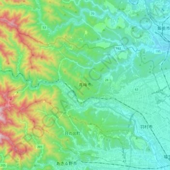
Name: Tokyo topographic map, elevation, terrain.

Location: Tokyo, Ome, Japan (35.75455 139.13716 35.85087 139.33036)

Average elevation: 1,007 ft

Minimum elevation: 262 ft

Maximum elevation: 3,415 ft

Other topographic maps

Click on a map to view its topography, its elevation and its terrain.

Mount Takao

Japan > Tokyo

Average elevation: 1,309 ft

Mount Takao

Japan > Tokyo

Average elevation: 1,309 ft

Iō Island

Japan > Tokyo

Average elevation: 89 ft

Iō Island

Japan > Tokyo

Average elevation: 89 ft

Iō Island

Japan > Tokyo

Average elevation: 89 ft

Tokyo International Airport

Japan > Tokyo

Average elevation: 7 ft

Mount Atago

Japan > Tokyo

Average elevation: 197 ft

Mount Nokogiri

Japan > Tokyo

Average elevation: 2,743 ft

Gear up for your next adventure:

🧤Tactile Hiking Gloves - Keep hands warm while operating GPS and smartphone screens
🚪Portable Camp Chair - Foldable chair for comfort at camp
🪶Fire Starter Kit - Reliable fire starter for survival and camping
🖼️Topo Map Wall Art - Decorative topographic prints of famous peaks and regions
🎒Trekking Poles - Sturdy poles for balance and stability on rough terrain

As an Amazon Associate, this site earns from qualifying purchases at no extra cost to you.