
Make a donation
Gear up for your next adventure:
As an Amazon Associate, this site earns from qualifying purchases at no extra cost to you.
Mount Takao topographic map
Click on the map to display elevation.
Make a donation
Gear up for your next adventure:
As an Amazon Associate, this site earns from qualifying purchases at no extra cost to you.
About this map
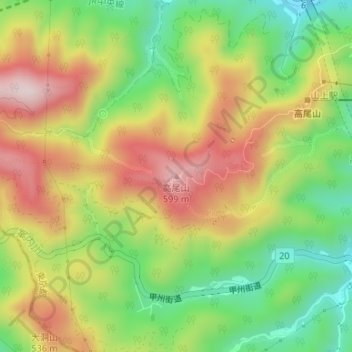
Name: Mount Takao topographic map, elevation, terrain.
Location: Mount Takao, Tokyo, 193-0841, Japan (35.62518 139.24364 35.62528 139.24374)
Average elevation: 1,309 ft
Minimum elevation: 679 ft
Maximum elevation: 2,008 ft
Make a donation
Gear up for your next adventure:
As an Amazon Associate, this site earns from qualifying purchases at no extra cost to you.
Other topographic maps
Click on a map to view its topography, its elevation and its terrain.
Make a donation
Gear up for your next adventure:
As an Amazon Associate, this site earns from qualifying purchases at no extra cost to you.
Make a donation
Gear up for your next adventure:
As an Amazon Associate, this site earns from qualifying purchases at no extra cost to you.
Miyakejima
The island is a stratovolcano with a granitic composite cone, dating from the late Pleistocene period, between 10,000 and 2,000 years ago. The island has a roughly circular coastline, 88.3 kilometers in length, with an average diameter of eight kilometers. The highest elevation Mount Oyama (雄山, Oyama-san)…
Average elevation: 551 ft
Make a donation
Gear up for your next adventure:
As an Amazon Associate, this site earns from qualifying purchases at no extra cost to you.