
Make a donation
Gear up for your next adventure:
As an Amazon Associate, this site earns from qualifying purchases at no extra cost to you.
Embrun topographic map
Click on the map to display elevation.
Make a donation
Gear up for your next adventure:
As an Amazon Associate, this site earns from qualifying purchases at no extra cost to you.
About this map
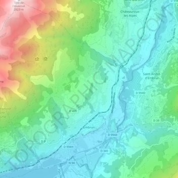
Name: Embrun topographic map, elevation, terrain.
Average elevation: 4,078 ft
Minimum elevation: 2,523 ft
Maximum elevation: 9,219 ft
Make a donation
Gear up for your next adventure:
As an Amazon Associate, this site earns from qualifying purchases at no extra cost to you.
Other topographic maps
Click on a map to view its topography, its elevation and its terrain.
Plan de la Loubiere
France > Provence-Alpes-Côte d'Azur > Hautes-Alpes > La Roche-de-Rame
Average elevation: 6,745 ft
Serre Chevalier
France > Provence-Alpes-Côte d'Azur > Hautes-Alpes > Puy-Saint-André
The maximum elevation for skiing is at Telesiege Yret at 2,800 m (9,190 ft) above sea level, and the minimum is 1,200 m (3,940 ft), a total vertical drop of 1,600 m (5,250 ft). One of the outstanding features of Serre Chevalier is the wooded nature of the slopes. The timber line is at 2,150 m (7,050 ft),…
Average elevation: 7,402 ft
Lucis
France > Provence-Alpes-Côte d'Azur > Hautes-Alpes > Villar-Saint-Pancrace
Average elevation: 4,350 ft
Col du Lautaret
France > Provence-Alpes-Côte d'Azur > Hautes-Alpes > Le Monêtier-les-Bains
From the west, the climb starts at Les Clapier, near Le Bourg-d'Oisans, from where the climb is 34.2 km (21.3 mi) long, gaining 1,312 m (4,304 ft) in altitude, at an average gradient of 3.8%, with the steepest section being at 7.5% in the first kilometre.
Average elevation: 7,418 ft
Make a donation
Gear up for your next adventure:
As an Amazon Associate, this site earns from qualifying purchases at no extra cost to you.
Le Villardon
France > Provence-Alpes-Côte d'Azur > Hautes-Alpes > Aubessagne
Average elevation: 3,488 ft
Orcières-Merlette
France > Provence-Alpes-Côte d'Azur > Hautes-Alpes > Orcières
Average elevation: 6,148 ft
Le Moulin
France > Provence-Alpes-Côte d'Azur > Hautes-Alpes > Saint-Firmin
Average elevation: 3,671 ft
Make a donation
Gear up for your next adventure:
As an Amazon Associate, this site earns from qualifying purchases at no extra cost to you.
Les Payas
France > Provence-Alpes-Côte d'Azur > Hautes-Alpes > Saint-Bonnet-en-Champsaur
Average elevation: 4,347 ft
Les Forests
France > Provence-Alpes-Côte d'Azur > Hautes-Alpes > Saint-Léger-les-Mélèzes
Average elevation: 4,537 ft
Les Chaussendents
France > Provence-Alpes-Côte d'Azur > Hautes-Alpes > La Chapelle-en-Valgaudémar
Average elevation: 5,312 ft
Make a donation
Gear up for your next adventure:
As an Amazon Associate, this site earns from qualifying purchases at no extra cost to you.
La Rua
France > Provence-Alpes-Côte d'Azur > Hautes-Alpes > Molines-en-Queyras
Average elevation: 6,503 ft
Les Allouviers
France > Provence-Alpes-Côte d'Azur > Hautes-Alpes > Gap > Romette
Average elevation: 3,140 ft
Make a donation
Gear up for your next adventure:
As an Amazon Associate, this site earns from qualifying purchases at no extra cost to you.
Station de Ski de Réallon
France > Provence-Alpes-Côte d'Azur > Hautes-Alpes > Réallon
Average elevation: 4,902 ft
Le Château d'Ancelle
France > Provence-Alpes-Côte d'Azur > Hautes-Alpes > Ancelle
Average elevation: 4,616 ft