
Make a donation
Gear up for your next adventure:
As an Amazon Associate, this site earns from qualifying purchases at no extra cost to you.
Chaillol 1600 topographic map
Click on the map to display elevation.
Make a donation
Gear up for your next adventure:
As an Amazon Associate, this site earns from qualifying purchases at no extra cost to you.
About this map
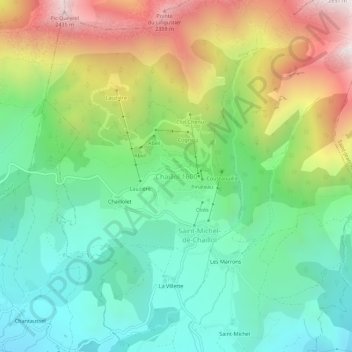
Name: Chaillol 1600 topographic map, elevation, terrain.
Average elevation: 5,463 ft
Minimum elevation: 4,019 ft
Maximum elevation: 8,104 ft
Make a donation
Gear up for your next adventure:
As an Amazon Associate, this site earns from qualifying purchases at no extra cost to you.
Other topographic maps
Click on a map to view its topography, its elevation and its terrain.
Vallouise
France > Provence-Alpes-Côte d'Azur > Hautes-Alpes > Vallouise-Pelvoux
Average elevation: 7,802 ft
Pelvoux
France > Provence-Alpes-Côte d'Azur > Hautes-Alpes > Vallouise-Pelvoux
Average elevation: 8,068 ft
Make a donation
Gear up for your next adventure:
As an Amazon Associate, this site earns from qualifying purchases at no extra cost to you.
Risoul
France > Provence-Alpes-Côte d'Azur > Hautes-Alpes
The resort has 55 ski lifts, including a cable car and 14 chairs. These give it an uplift capacity of 57,000 skiers per hour. The resort is linked to Vars through the Forêt Blanche ski area giving a total of 180 km (110 mi) of ski runs situated between 1650 and 2750 metres altitude.
Average elevation: 5,787 ft
Make a donation
Gear up for your next adventure:
As an Amazon Associate, this site earns from qualifying purchases at no extra cost to you.
Saint-Bonnet-en-Champsaur
France > Provence-Alpes-Côte d'Azur > Hautes-Alpes
Average elevation: 3,990 ft
Make a donation
Gear up for your next adventure:
As an Amazon Associate, this site earns from qualifying purchases at no extra cost to you.
Saint-Eusèbe-en-Champsaur
France > Provence-Alpes-Côte d'Azur > Hautes-Alpes > Aubessagne
Average elevation: 3,376 ft
Make a donation
Gear up for your next adventure:
As an Amazon Associate, this site earns from qualifying purchases at no extra cost to you.
Saint-Léger-les-Mélèzes
France > Provence-Alpes-Côte d'Azur > Hautes-Alpes
Average elevation: 4,186 ft
Make a donation
Gear up for your next adventure:
As an Amazon Associate, this site earns from qualifying purchases at no extra cost to you.