
South Philadelphia topographic map
Click on the map to display elevation.
About this map
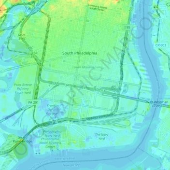
Name: South Philadelphia topographic map, elevation, terrain.
Average elevation: 20 ft
Minimum elevation: -20 ft
Maximum elevation: 112 ft
Philadelphia County trails, hiking, mountain biking, running and outdoor activities
Other topographic maps
Click on a map to view its topography, its elevation and its terrain.
Philadelphia
United States > Pennsylvania > Philadelphia County > Philadelphia
Average elevation: 115 ft
Franklin Delano Roosevelt Park
United States > Pennsylvania > Philadelphia County > Philadelphia
Average elevation: 16 ft
Aviv's Garden
United States > Pennsylvania > Philadelphia County > Philadelphia
Average elevation: 49 ft