
Make a donation
Gear up for your next adventure:
As an Amazon Associate, this site earns from qualifying purchases at no extra cost to you.
Sullivan's Island topographic map
Click on the map to display elevation.
Make a donation
Gear up for your next adventure:
As an Amazon Associate, this site earns from qualifying purchases at no extra cost to you.
About this map
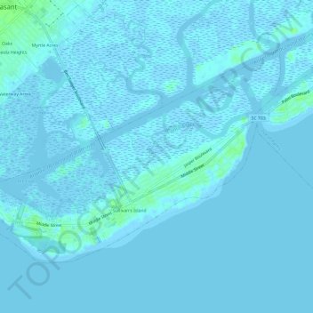
Name: Sullivan's Island topographic map, elevation, terrain.
Average elevation: 3 ft
Minimum elevation: -10 ft
Maximum elevation: 30 ft
Charleston County trails, hiking, mountain biking, running and outdoor activities
Make a donation
Gear up for your next adventure:
As an Amazon Associate, this site earns from qualifying purchases at no extra cost to you.
Other topographic maps
Click on a map to view its topography, its elevation and its terrain.
Sullivans Island
United States > South Carolina > Charleston County > Sullivan"s Island > Sullivans Island
Average elevation: 3 ft
Charleston Farms
United States > South Carolina > Charleston County > North Charleston
Average elevation: 26 ft
Hibernian Heights
United States > South Carolina > Charleston County > Charleston
Average elevation: 10 ft
Make a donation
Gear up for your next adventure:
As an Amazon Associate, this site earns from qualifying purchases at no extra cost to you.
Seabrook Island
United States > South Carolina > Charleston County > Seabrook Island
Average elevation: 7 ft
Stafford Heights
United States > South Carolina > Charleston County > Charleston
Average elevation: 16 ft
Scanlonville
United States > South Carolina > Charleston County > Mount Pleasant
Average elevation: 13 ft
Make a donation
Gear up for your next adventure:
As an Amazon Associate, this site earns from qualifying purchases at no extra cost to you.
Sullivan's Island
United States > South Carolina > Charleston County > Sullivan's Island
Average elevation: 7 ft
Charleston Heights
United States > South Carolina > Charleston County > North Charleston
Average elevation: 16 ft
Make a donation
Gear up for your next adventure:
As an Amazon Associate, this site earns from qualifying purchases at no extra cost to you.
Forest Acres West
United States > South Carolina > Charleston County > Charleston
Average elevation: 16 ft
Otranto
United States > South Carolina > Charleston County > North Charleston
Average elevation: 23 ft
Make a donation
Gear up for your next adventure:
As an Amazon Associate, this site earns from qualifying purchases at no extra cost to you.
North Charleston
United States > South Carolina > Charleston County > North Charleston
Average elevation: 16 ft
Cherokee Place
United States > South Carolina > Charleston County > North Charleston
Average elevation: 16 ft
Waterway Arms
United States > South Carolina > Charleston County > Mount Pleasant
Average elevation: 7 ft
Make a donation
Gear up for your next adventure:
As an Amazon Associate, this site earns from qualifying purchases at no extra cost to you.
Osceola Oaks
United States > South Carolina > Charleston County > Mount Pleasant
Average elevation: 10 ft
Make a donation
Gear up for your next adventure:
As an Amazon Associate, this site earns from qualifying purchases at no extra cost to you.
Hunley Park
United States > South Carolina > Charleston County > North Charleston
Average elevation: 23 ft
Grove Creek Village
United States > South Carolina > Charleston County > Charleston
Average elevation: 10 ft
Saint Andrews
United States > South Carolina > Charleston County > Charleston
Average elevation: 10 ft
Make a donation
Gear up for your next adventure:
As an Amazon Associate, this site earns from qualifying purchases at no extra cost to you.
Hickory Hall Plantation
United States > South Carolina > Charleston County > Charleston
Average elevation: 16 ft
Wando Estates
United States > South Carolina > Charleston County > Mount Pleasant
Average elevation: 16 ft
Ashley Hall Manor
United States > South Carolina > Charleston County > Charleston
Average elevation: 16 ft
Make a donation
Gear up for your next adventure:
As an Amazon Associate, this site earns from qualifying purchases at no extra cost to you.
Fort Sumter
United States > South Carolina > Charleston County > Sullivan's Island
Average elevation: 0 ft
Fort Moultrie
United States > South Carolina > Charleston County > Sullivan's Island
Average elevation: 0 ft
Harrison Acres
United States > South Carolina > Charleston County > Charleston
Average elevation: 13 ft
Make a donation
Gear up for your next adventure:
As an Amazon Associate, this site earns from qualifying purchases at no extra cost to you.
Dorchester
United States > South Carolina > Charleston County > North Charleston
Average elevation: 16 ft
Make a donation
Gear up for your next adventure:
As an Amazon Associate, this site earns from qualifying purchases at no extra cost to you.
Moultrie Heights
United States > South Carolina > Charleston County > Mount Pleasant
Average elevation: 10 ft
Oakcrest
United States > South Carolina > Charleston County > Charleston > Oakcrest
Average elevation: 13 ft
Make a donation
Gear up for your next adventure:
As an Amazon Associate, this site earns from qualifying purchases at no extra cost to you.
Liberty Hill
United States > South Carolina > Charleston County > North Charleston
Average elevation: 23 ft
Kiawah Island
United States > South Carolina > Charleston County > Kiawah Island
Average elevation: 3 ft
Seaside
United States > South Carolina > Charleston County > Charleston > Seaside
Average elevation: 7 ft
Wragg Borough Homes
United States > South Carolina > Charleston County > Charleston > Wragg Borough Homes
Average elevation: 10 ft
Make a donation
Gear up for your next adventure:
As an Amazon Associate, this site earns from qualifying purchases at no extra cost to you.
Maryville
United States > South Carolina > Charleston County > Charleston > Maryville
Average elevation: 13 ft
Make a donation
Gear up for your next adventure:
As an Amazon Associate, this site earns from qualifying purchases at no extra cost to you.
Laroche
United States > South Carolina > Charleston County > Hollywood > Laroche
Average elevation: 16 ft
Shoreline Farms
United States > South Carolina > Charleston County > Shoreline Farms
Average elevation: 13 ft
Fenwick Crossroads
United States > South Carolina > Charleston County > Charleston > Fenwick Crossroads
Average elevation: 16 ft
Ashley Junction
United States > South Carolina > Charleston County > North Charleston
Average elevation: 23 ft
Make a donation
Gear up for your next adventure:
As an Amazon Associate, this site earns from qualifying purchases at no extra cost to you.
Hickory Shadows
United States > South Carolina > Charleston County > Mount Pleasant
Average elevation: 13 ft
Daniel Jenkins Homes
United States > South Carolina > Charleston County > North Charleston > Daniel Jenkins Homes
Average elevation: 13 ft
Osceola Heights
United States > South Carolina > Charleston County > Mount Pleasant
Average elevation: 10 ft
Make a donation
Gear up for your next adventure:
As an Amazon Associate, this site earns from qualifying purchases at no extra cost to you.
Deerwood Heights
United States > South Carolina > Charleston County > North Charleston
Average elevation: 26 ft
Forest Hills
United States > South Carolina > Charleston County > North Charleston
Average elevation: 23 ft