Geolocate

Painswick topographic map

Click on the map to display elevation.

About this map

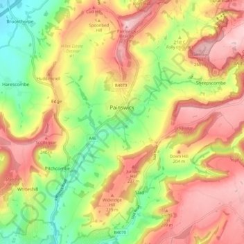
Name: Painswick topographic map, elevation, terrain.

Location: Painswick, Stroud, Gloucestershire, England, United Kingdom (51.75058 -2.22678 51.81336 -2.13845)

Average elevation: 535 ft

Minimum elevation: 118 ft

Maximum elevation: 919 ft

Other topographic maps

Click on a map to view its topography, its elevation and its terrain.

Millend

United Kingdom > England > Gloucestershire > Stroud > North Nibley

Average elevation: 400 ft

Whiteshill

United Kingdom > England > Gloucestershire > Stroud

Average elevation: 433 ft

Stroud

United Kingdom > England > Gloucestershire > Stroud

Average elevation: 443 ft

Gear up for your next adventure:

🏔️Mountain Trail Maps - High‑detail maps for popular peaks
🧥Men's Rain Shells - Premium waterproof and breathable jackets for mountain weather
📶Satellite Messenger - Communication device off‑grid
🪄Magnetic Compass - Accurate compass for navigation
Solar GPS Watches - Advanced multisport watches with built-in topographic maps

As an Amazon Associate, this site earns from qualifying purchases at no extra cost to you.