Geolocate

Inchbrook topographic map

Click on the map to display elevation.

About this map

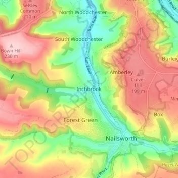
Name: Inchbrook topographic map, elevation, terrain.

Location: Inchbrook, Stroud, Gloucestershire, England, GL5 5HN, United Kingdom (51.68636 -2.25032 51.72636 -2.21032)

Average elevation: 463 ft

Minimum elevation: 148 ft

Maximum elevation: 764 ft

Other topographic maps

Click on a map to view its topography, its elevation and its terrain.

Slimbridge

United Kingdom > England > Gloucestershire > Stroud

Average elevation: 46 ft

Uley

United Kingdom > England > Gloucestershire > Stroud

Average elevation: 459 ft

Lypiatt Park

United Kingdom > England > Gloucestershire > Stroud > Eastcombe

Average elevation: 682 ft

Pitchcombe

United Kingdom > England > Gloucestershire > Stroud

Average elevation: 479 ft

Arlingham

United Kingdom > England > Gloucestershire > Stroud

Average elevation: 46 ft

Kingswood

United Kingdom > England > Gloucestershire > Stroud

Average elevation: 213 ft

Leonard Stanley

United Kingdom > England > Gloucestershire > Stroud

Average elevation: 203 ft

Whitminster

United Kingdom > England > Gloucestershire > Stroud

Average elevation: 66 ft

Woodchester

United Kingdom > England > Gloucestershire > Stroud

Average elevation: 423 ft

Cranham

United Kingdom > England > Gloucestershire > Stroud

Average elevation: 643 ft

Chalford

United Kingdom > England > Gloucestershire > Stroud > Chalford

Average elevation: 558 ft

Stinchcombe

United Kingdom > England > Gloucestershire > Stroud

Average elevation: 256 ft

Alderley

United Kingdom > England > Gloucestershire > Stroud

In A Topographical Dictionary of England by Samuel Lewis published in 1831, Alderley is described thus.

Average elevation: 312 ft

Cam

United Kingdom > England > Gloucestershire > Stroud > Cam

Average elevation: 226 ft

Gear up for your next adventure:

🧦Hiking Socks - Comfortable socks to prevent blisters on long hikes
🧦Merino Wool Socks - Moisture-wicking, blister-preventing socks for long treks
🧣Merino Neck Gaiters - Multi-functional headwear for wind and sun protection
🌎3D Topographic Globes - Raised relief globes for a tactile understanding of geography
🧭Hiking Compass - Precision compass for reliable navigation in the wilderness

As an Amazon Associate, this site earns from qualifying purchases at no extra cost to you.