
Shipley topographic map
Click on the map to display elevation.
About this map
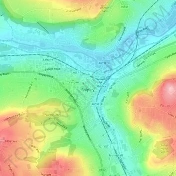
Name: Shipley topographic map, elevation, terrain.
Average elevation: 397 ft
Minimum elevation: 203 ft
Maximum elevation: 738 ft
Other topographic maps
Click on a map to view its topography, its elevation and its terrain.
Ponden Reservoir
United Kingdom > England > Bradford > Keighley > Stanbury
Average elevation: 1,027 ft
Bingley South Bog
United Kingdom > England > Bradford > Bingley > Cottingley
Average elevation: 374 ft
Cliffe Castle Park
United Kingdom > England > Bradford > Keighley > Long Lee
Average elevation: 449 ft
Shipley High Moor
United Kingdom > England > Bradford > Bingley > Cottingley
Average elevation: 584 ft
Cackleshaw
United Kingdom > England > Bradford > Keighley > Oakworth > Cackleshaw
Average elevation: 719 ft