
Make a donation
Gear up for your next adventure:
As an Amazon Associate, this site earns from qualifying purchases at no extra cost to you.
Port Clements topographic map
Click on the map to display elevation.
Make a donation
Gear up for your next adventure:
As an Amazon Associate, this site earns from qualifying purchases at no extra cost to you.
About this map
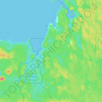
Name: Port Clements topographic map, elevation, terrain.
Average elevation: 72 ft
Minimum elevation: 0 ft
Maximum elevation: 308 ft
Make a donation
Gear up for your next adventure:
As an Amazon Associate, this site earns from qualifying purchases at no extra cost to you.
Other topographic maps
Click on a map to view its topography, its elevation and its terrain.
Kitkatla
Canada > British Columbia > North Coast Regional District > Area C (South Skeena)
Average elevation: 46 ft
Mount McGrath
Canada > British Columbia > North Coast Regional District > Area C (South Skeena)
Average elevation: 1,293 ft
Skeena
Canada > British Columbia > North Coast Regional District > Area A (North Skeena)
Average elevation: 200 ft
Lax Kw'alaams
Canada > British Columbia > North Coast Regional District > Area A (North Skeena)
Average elevation: 207 ft
Make a donation
Gear up for your next adventure:
As an Amazon Associate, this site earns from qualifying purchases at no extra cost to you.
Taaw Tldáaw
Canada > British Columbia > North Coast Regional District > Area D (Graham Island)
Average elevation: 26 ft
Alford Point
Canada > British Columbia > North Coast Regional District > Area E (Moresby Island)
Average elevation: 200 ft
Coast Mountains
Canada > British Columbia > North Coast Regional District > Area A (North Skeena)
Average elevation: 1,096 ft
Sandspit
Canada > British Columbia > North Coast Regional District > Area E (Moresby Island)
Average elevation: 43 ft
Make a donation
Gear up for your next adventure:
As an Amazon Associate, this site earns from qualifying purchases at no extra cost to you.
Cape Edensaw
Canada > British Columbia > North Coast Regional District > Area D (Graham Island)
Average elevation: 10 ft
Sandspit
Canada > British Columbia > North Coast Regional District > Area E (Moresby Island)
Average elevation: 43 ft
Client Reefs
Canada > British Columbia > North Coast Regional District > Area C (South Skeena)
Average elevation: 0 ft
Ship Island
Canada > British Columbia > North Coast Regional District > Area D (Graham Island)
Average elevation: 13 ft
Make a donation
Gear up for your next adventure:
As an Amazon Associate, this site earns from qualifying purchases at no extra cost to you.
Watson Island
Canada > British Columbia > North Coast Regional District > Prince Rupert > Watson Island
Average elevation: 341 ft
Jalun Lake
Canada > British Columbia > North Coast Regional District > Area D (Graham Island)
Average elevation: 679 ft