Geolocate

Wausau topographic map

Click on the map to display elevation.

About this map

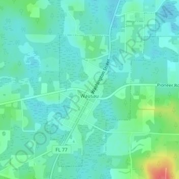
Name: Wausau topographic map, elevation, terrain.

Location: Wausau, Washington County, Florida, United States (30.62153 -85.59626 30.64472 -85.57717)

Average elevation: 98 ft

Minimum elevation: 52 ft

Maximum elevation: 253 ft

Washington County trails, hiking, mountain biking, running and outdoor activities

Other topographic maps

Click on a map to view its topography, its elevation and its terrain.

Live Oak

United States > Florida > Washington County

Average elevation: 46 ft

Greenhead

United States > Florida > Washington County

Average elevation: 125 ft

Grantham

United States > Florida > Washington County > Grantham

Average elevation: 79 ft

Gear up for your next adventure:

📷Action Camera - Capture your outdoor adventures in HD
📚USA Hiking Guide Books - Top trail guides and map books
🧭Compass with Lanyard - Easy‑carry compass for navigation
🪑Portable Camp Table - Compact table for campsite meals
🧺Microfiber Travel Towels - Compact and fast-drying towels for trail use

As an Amazon Associate, this site earns from qualifying purchases at no extra cost to you.