
Thank you for supporting this site ❤️
Make a donation
Make a donation
Gear up for your next adventure:
As an Amazon Associate, this site earns from qualifying purchases at no extra cost to you.
Bhingri topographic map
Click on the map to display elevation.
Thank you for supporting this site ❤️
Make a donation
Make a donation
Gear up for your next adventure:
As an Amazon Associate, this site earns from qualifying purchases at no extra cost to you.
About this map
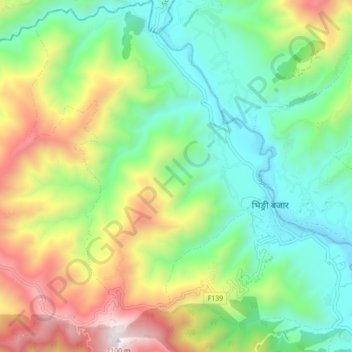
Name: Bhingri topographic map, elevation, terrain.
Location: Bhingri, Sworgadwary, Pyuthan, Lumbini Province, Nepal (28.11592 82.65189 28.19287 82.72797)
Average elevation: 3,694 ft
Minimum elevation: 1,975 ft
Maximum elevation: 6,906 ft
Thank you for supporting this site ❤️
Make a donation
Make a donation
Gear up for your next adventure:
As an Amazon Associate, this site earns from qualifying purchases at no extra cost to you.