Geolocate

Hamersville topographic map

Click on the map to display elevation.

About this map

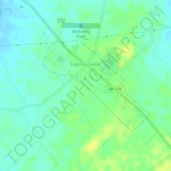
Name: Hamersville topographic map, elevation, terrain.

Location: Hamersville, Brown County, Ohio, United States (38.91024 -83.99636 38.92476 -83.97449)

Average elevation: 961 ft

Minimum elevation: 935 ft

Maximum elevation: 997 ft

Brown County trails, hiking, mountain biking, running and outdoor activities

Other topographic maps

Click on a map to view its topography, its elevation and its terrain.

Decatur

United States > Ohio > Brown County

Average elevation: 889 ft

Lake Lorelei

United States > Ohio > Brown County > Vera Cruz

Average elevation: 945 ft

Lake Waynoka

United States > Ohio > Brown County

Average elevation: 1,020 ft

Chasetown

United States > Ohio > Brown County

Average elevation: 945 ft

Vera Cruz

United States > Ohio > Brown County

Average elevation: 928 ft

Gear up for your next adventure:

📷Action Cameras - Rugged cameras to document your journeys across rugged terrain
🧭Hiking Compass - Precision compass for reliable navigation in the wilderness
🥇GPS Hiking Watch - Multi‑sport GPS watch with navigation and trail tracking
🗺️Topographic Maps - Detailed topo maps for hiking, exploring and outdoor navigation
🏕️Tent Footprint - Protect your tent base from wear

As an Amazon Associate, this site earns from qualifying purchases at no extra cost to you.