Geolocate

Decatur topographic map

Click on the map to display elevation.

About this map

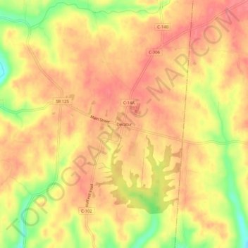
Name: Decatur topographic map, elevation, terrain.

Location: Decatur, Brown County, Ohio, 45115, United States (38.79563 -83.72381 38.83563 -83.68381)

Average elevation: 889 ft

Minimum elevation: 728 ft

Maximum elevation: 961 ft

Brown County trails, hiking, mountain biking, running and outdoor activities

Other topographic maps

Click on a map to view its topography, its elevation and its terrain.

St. Martin

United States > Ohio > Brown County

Average elevation: 971 ft

Russellville

United States > Ohio > Brown County

Average elevation: 945 ft

Lake Lorelei

United States > Ohio > Brown County > Vera Cruz

Average elevation: 945 ft

Lake Waynoka

United States > Ohio > Brown County

Average elevation: 1,020 ft

Mount Orab

United States > Ohio > Brown County

Average elevation: 942 ft

Higginsport

United States > Ohio > Brown County

Average elevation: 597 ft

Hamersville

United States > Ohio > Brown County

Average elevation: 961 ft

Aberdeen

United States > Ohio > Brown County

Average elevation: 692 ft

Gear up for your next adventure:

Backpacking Tent - Lightweight and durable tent for multi‑day hikes
🎒Trekking Poles - Sturdy poles for balance and stability on rough terrain
🪶Camping Sleeping Pad - Comfortable sleeping pad for backpacking
🌡️Portable Weather Meter - Track weather conditions on the trail
🪶Trail Camera - Capture wildlife on your hikes

As an Amazon Associate, this site earns from qualifying purchases at no extra cost to you.