Geolocate

Alaska topographic map

Click on the map to display elevation.

About this map

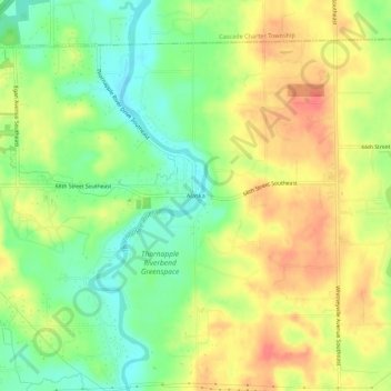
Name: Alaska topographic map, elevation, terrain.

Location: Alaska, Caledonia Township, Kent County, Michigan, United States (42.82003 -85.49808 42.86003 -85.45808)

Average elevation: 755 ft

Minimum elevation: 659 ft

Maximum elevation: 846 ft

Kent County trails, hiking, mountain biking, running and outdoor activities

Other topographic maps

Click on a map to view its topography, its elevation and its terrain.

Forest Hills

United States > Michigan > Kent County > Ada Township

Average elevation: 751 ft

Pickerel Lake

United States > Michigan > Kent County

Average elevation: 879 ft

Nelson Township

United States > Michigan > Kent County

Average elevation: 902 ft

Oakfield Township

United States > Michigan > Kent County

Average elevation: 869 ft

Lake Leota

United States > Michigan > Kent County > Walker

Average elevation: 653 ft

Sparta Township

United States > Michigan > Kent County

Average elevation: 807 ft

Ada Township

United States > Michigan > Kent County

Average elevation: 748 ft

Byron Center

United States > Michigan > Kent County > Byron Center

Average elevation: 738 ft

Gaines Township

United States > Michigan > Kent County

Average elevation: 797 ft

Solon Township

United States > Michigan > Kent County

Average elevation: 863 ft

Cordes Lake

United States > Michigan > Kent County

Average elevation: 902 ft

Scram Lake

United States > Michigan > Kent County

Average elevation: 886 ft

Gear up for your next adventure:

🌎3D Topographic Globes - Raised relief globes for a tactile understanding of geography
📱Solar Portable Charger - Solar power bank for charging devices off‑grid
🦶Hiking Gaiters - Keep debris and water out of your boots
🎒Gear Packing Cubes - Organize your backpack efficiently
🎒Trekking Poles - Sturdy poles for balance and stability on rough terrain

As an Amazon Associate, this site earns from qualifying purchases at no extra cost to you.