Geolocate

Solon Township topographic map

Click on the map to display elevation.

About this map

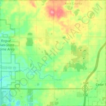
Name: Solon Township topographic map, elevation, terrain.

Location: Solon Township, Kent County, Michigan, United States (43.20502 -85.67294 43.29426 -85.55107)

Average elevation: 863 ft

Minimum elevation: 748 ft

Maximum elevation: 1,063 ft

Kent County trails, hiking, mountain biking, running and outdoor activities

Other topographic maps

Click on a map to view its topography, its elevation and its terrain.

Kentwood

United States > Michigan > Kent County > Kentwood

Average elevation: 715 ft

Alton

United States > Michigan > Kent County > Vergennes Township

Average elevation: 833 ft

Cordes Lake

United States > Michigan > Kent County

Average elevation: 902 ft

Scram Lake

United States > Michigan > Kent County

Average elevation: 886 ft

Lake Leota

United States > Michigan > Kent County > Walker

Average elevation: 653 ft

Alaska

United States > Michigan > Kent County

Average elevation: 755 ft

Alto

United States > Michigan > Kent County

Average elevation: 827 ft

Ada

United States > Michigan > Kent County

Average elevation: 682 ft

Gear up for your next adventure:

🔥Plasma Lighters - Windproof lighters that work in any weather condition
⛑️Personal Locator Beacon - Safety beacon for emergencies
Backpacking Tents - Weight-optimized shelters for multi-day topographic surveys
🔌USB Car Charger - Car charger for on‑the‑go power needs
🥤Water Filter Bottle - All‑in‑one filter bottle for safe hydration

As an Amazon Associate, this site earns from qualifying purchases at no extra cost to you.