Make a donation
Gear up for your next adventure:
As an Amazon Associate, this site earns from qualifying purchases at no extra cost to you.
Shusha topographic map
Click on the map to display elevation.
Make a donation
Gear up for your next adventure:
As an Amazon Associate, this site earns from qualifying purchases at no extra cost to you.
Shusha
Shusha (Azerbaijani: Şuşa, (listen)) or Shushi (Armenian: Շուշի) is a city in Azerbaijan, in the disputed region of Nagorno-Karabakh. Situated at an altitude of 1,400–1,800 metres (4,600–5,900 ft) in the Karabakh mountains, the city was a mountain resort in the Soviet era.
Make a donation
Gear up for your next adventure:
As an Amazon Associate, this site earns from qualifying purchases at no extra cost to you.
About this map
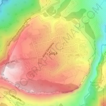
Name: Shusha topographic map, elevation, terrain.
Location: Shusha, Shusha District, Karabakh, Azerbaijan (39.74850 46.73213 39.76945 46.76343)
Average elevation: 4,157 ft
Minimum elevation: 3,028 ft
Maximum elevation: 5,043 ft
Make a donation
Gear up for your next adventure:
As an Amazon Associate, this site earns from qualifying purchases at no extra cost to you.
Other topographic maps
Click on a map to view its topography, its elevation and its terrain.
Make a donation
Gear up for your next adventure:
As an Amazon Associate, this site earns from qualifying purchases at no extra cost to you.
