
Togh topographic map
Click on the map to display elevation.
About this map
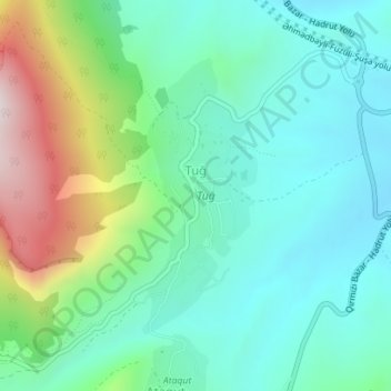
Name: Togh topographic map, elevation, terrain.
Location: Togh, Khojavend District, Karabakh, Azerbaijan (39.57531 46.96057 39.59441 46.97094)
Average elevation: 2,867 ft
Minimum elevation: 2,221 ft
Maximum elevation: 4,633 ft
Other topographic maps
Click on a map to view its topography, its elevation and its terrain.
Shusha
Shusha (Azerbaijani: Şuşa, (listen)) or Shushi (Armenian: Շուշի) is a city in Azerbaijan, in the disputed region of Nagorno-Karabakh. Situated at an altitude of 1,400–1,800 metres (4,600–5,900 ft) in the Karabakh mountains, the city was a mountain resort in the Soviet era.
Average elevation: 4,157 ft
Hadrut Province
Hadrut Province formed the breakaway Republic of Artsakh's southern border and is one of its most mountainous parts. Villages were primarily found along two river valleys and scattered in lower elevations on the very southern fringe. Excavations of the Azokh Cave showed that humans have inhabited this area for…
Average elevation: 3,658 ft