Geolocate

Green Acres topographic map

Click on the map to display elevation.

About this map

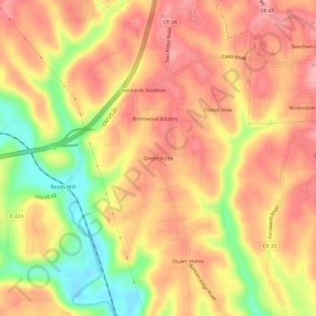
Name: Green Acres topographic map, elevation, terrain.

Location: Green Acres, Jefferson County, Ohio, 43953, United States (40.34368 -80.75258 40.38368 -80.71258)

Average elevation: 1,073 ft

Minimum elevation: 791 ft

Maximum elevation: 1,240 ft

Jefferson County trails, hiking, mountain biking, running and outdoor activities

Other topographic maps

Click on a map to view its topography, its elevation and its terrain.

Tiltonsville

United States > Ohio > Jefferson County

Average elevation: 823 ft

Toronto

United States > Ohio > Jefferson County

Average elevation: 909 ft

Adena

United States > Ohio > Jefferson County

Average elevation: 1,017 ft

Richmond

United States > Ohio > Jefferson County

Average elevation: 1,194 ft

Wintersville

United States > Ohio > Jefferson County

Average elevation: 1,135 ft

Irondale

United States > Ohio > Jefferson County > Irondale

Average elevation: 1,010 ft

Bloomingdale

United States > Ohio > Jefferson County

Average elevation: 1,171 ft

Gear up for your next adventure:

🔪Outdoor Multitools - Essential survival tools for gear repair and field use
🛏️Cold Weather Sleeping Bag - Warm sleeping bag for cold conditions
🧭Orienteering Set - Complete compass and map reading kit
🔌USB Car Charger - Car charger for on‑the‑go power needs
🔭Compact Binoculars - HD vision for scouting terrain and identifying distant landmarks

As an Amazon Associate, this site earns from qualifying purchases at no extra cost to you.