Geolocate

Adena topographic map

Click on the map to display elevation.

About this map

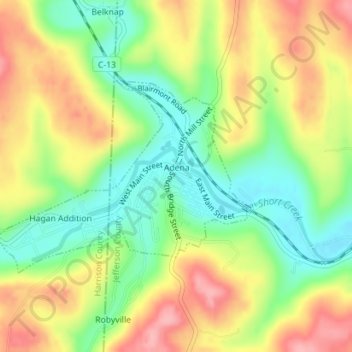
Name: Adena topographic map, elevation, terrain.

Location: Adena, Jefferson County, Ohio, United States (40.21058 -80.89110 40.22537 -80.86581)

Average elevation: 1,017 ft

Minimum elevation: 823 ft

Maximum elevation: 1,234 ft

Jefferson County trails, hiking, mountain biking, running and outdoor activities

Other topographic maps

Click on a map to view its topography, its elevation and its terrain.

Wolf Run

United States > Ohio > Jefferson County

Average elevation: 1,178 ft

Hammondsville

United States > Ohio > Jefferson County

Average elevation: 961 ft

Green Acres

United States > Ohio > Jefferson County

Average elevation: 1,073 ft

La Belle

United States > Ohio > Jefferson County > Steubenville

Average elevation: 876 ft

Beechwood

United States > Ohio > Jefferson County > Wintersville

Average elevation: 1,142 ft

Gear up for your next adventure:

❄️Traction Cleats - Prevent slips on icy trails during winter hikes
🥘Titanium Cookware - Durable, featherlight pots and pans for backpacking
🧭Orienteering Set - Complete compass and map reading kit
🗺️NatGeo Topo Maps - High-quality waterproof printed topographic maps of US Parks
📡Handheld GPS Device - Reliable handheld GPS for outdoor navigation

As an Amazon Associate, this site earns from qualifying purchases at no extra cost to you.