
Ava topographic map
Click on the map to display elevation.
Ava
Ava is located in the southern portion of the Missouri Ozarks within the southern escarpment of the Salem Plateau. The lakes of the White River basin of northern Arkansas and southern Missouri lie to the south. The town is at the intersection of Missouri highways 5, 14 and 76. Mansfield is 13 miles to the north and Gainesville is approximately 30 miles south. Elevation of the town varies from 1,150 to 1,400 feet (350 to 430 m).
About this map
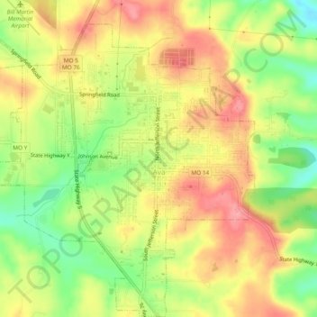
Name: Ava topographic map, elevation, terrain.
Location: Ava, Douglas County, Missouri, United States (36.93461 -92.69199 36.97233 -92.64575)
Average elevation: 1,286 ft
Minimum elevation: 1,106 ft
Maximum elevation: 1,430 ft
Douglas County trails, hiking, mountain biking, running and outdoor activities
Other topographic maps
Click on a map to view its topography, its elevation and its terrain.