
Make a donation
Gear up for your next adventure:
As an Amazon Associate, this site earns from qualifying purchases at no extra cost to you.
Chihuahua topographic map
Click on the map to display elevation.
Make a donation
Gear up for your next adventure:
As an Amazon Associate, this site earns from qualifying purchases at no extra cost to you.
About this map
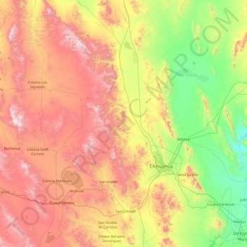
Name: Chihuahua topographic map, elevation, terrain.
Location: Chihuahua, Mexico (28.09585 -106.62191 29.78486 -105.70281)
Average elevation: 5,758 ft
Minimum elevation: 3,442 ft
Maximum elevation: 9,587 ft
Make a donation
Gear up for your next adventure:
As an Amazon Associate, this site earns from qualifying purchases at no extra cost to you.
Other topographic maps
Click on a map to view its topography, its elevation and its terrain.
Cerro Mohinora
Mexico > Chihuahua > Guadalupe y Calvo
Cerro Mohinora is an extinct volcano that is part of the Sierra Madre Occidental mountain range in the Mexican state of Chihuahua located in the municipality of Guadalupe y Calvo. Cerro Mohinora is the highest point in the state of Chihuahua reaching an elevation of 3,300 m (10,827 ft) above sea level. The…
Average elevation: 9,495 ft
Make a donation
Gear up for your next adventure:
As an Amazon Associate, this site earns from qualifying purchases at no extra cost to you.
Make a donation
Gear up for your next adventure:
As an Amazon Associate, this site earns from qualifying purchases at no extra cost to you.
Make a donation
Gear up for your next adventure:
As an Amazon Associate, this site earns from qualifying purchases at no extra cost to you.