
龙安区 topographic map
Interactive map
Click on the map to display elevation.
About this map
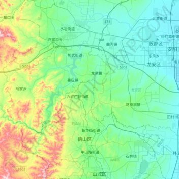
Name: 龙安区 topographic map, elevation, terrain.
Location: 龙安区, 安阳市, Henan, Chine (35.95795 113.98308 36.11188 114.34859)
Average elevation: 669 ft
Minimum elevation: 230 ft
Maximum elevation: 2,185 ft
Other topographic maps
Click on a map to view its topography, its elevation and its terrain.
District de Zhongyuan
District de Zhongyuan, Zhengzhou, Henan, Chine
Average elevation: 358 ft
District d'Erqi
District d'Erqi, Zhengzhou, Henan, Chine
Average elevation: 502 ft
Shangqiu
Chine > Henan > Xian de Sui > Shangqiu
Shangqiu, Xian de Sui, Henan, Chine
Average elevation: 187 ft