
华龙区 topographic map
Interactive map
Click on the map to display elevation.
About this map
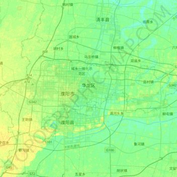
Name: 华龙区 topographic map, elevation, terrain.
Location: 华龙区, Puyang, Henan, Chine (35.67897 114.87862 35.86293 115.25553)
Average elevation: 174 ft
Minimum elevation: 154 ft
Maximum elevation: 200 ft
Other topographic maps
Click on a map to view its topography, its elevation and its terrain.
District de Zhongyuan
District de Zhongyuan, Zhengzhou, Henan, Chine
Average elevation: 358 ft
District d'Erqi
District d'Erqi, Zhengzhou, Henan, Chine
Average elevation: 502 ft
Shangqiu
Chine > Henan > Xian de Sui > Shangqiu
Shangqiu, Xian de Sui, Henan, Chine
Average elevation: 187 ft