
Macks Creek topographic map
Interactive map
Click on the map to display elevation.
About this map
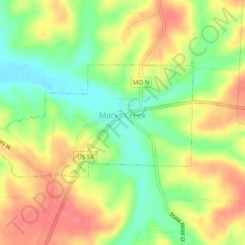
Name: Macks Creek topographic map, elevation, terrain.
Location: Macks Creek, Camden County, Missouri, United States (37.95928 -92.98817 37.97197 -92.95947)
Average elevation: 955 ft
Minimum elevation: 843 ft
Maximum elevation: 1,056 ft
Camden County trails, hiking, mountain biking, running and outdoor activities
Other topographic maps
Click on a map to view its topography, its elevation and its terrain.