
Friedenswald topographic map
Click on the map to display elevation.
About this map
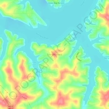
Name: Friedenswald topographic map, elevation, terrain.
Location: Friedenswald, Camden County, Missouri, 65052, United States (38.05389 -92.78263 38.09389 -92.74263)
Average elevation: 741 ft
Minimum elevation: 643 ft
Maximum elevation: 938 ft
Camden County trails, hiking, mountain biking, running and outdoor activities
Other topographic maps
Click on a map to view its topography, its elevation and its terrain.
Lake Of The Ozarks
United States > Missouri > Camden County > Osage Beach
The lake was created by the construction of the 2,543-foot (775 m) long Bagnell Dam by the Union Electric Company of St. Louis, Missouri. The principal engineering firm was Stone and Webster. Construction began August 8, 1929, and was completed in April 1931; the lake reached spillway elevation on May 20, 1931.
Average elevation: 869 ft
Linn Creek
United States > Missouri > Camden County
In 1929 it was announced that the Bagnell Dam would be constructed and the town would be flooded, causing controversy among the city's citizens. Almost all of the buildings were demolished, and the city was moved to a higher elevation, losing its designation as the county seat.
Average elevation: 820 ft