Geolocate

Clinton topographic map

Click on the map to display elevation.

About this map

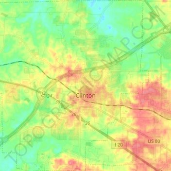
Name: Clinton topographic map, elevation, terrain.

Location: Clinton, Hinds County, Mississippi, United States (32.29334 -90.39943 32.40055 -90.27484)

Average elevation: 308 ft

Minimum elevation: 213 ft

Maximum elevation: 423 ft

Hinds County trails, hiking, mountain biking, running and outdoor activities

Other topographic maps

Click on a map to view its topography, its elevation and its terrain.

Brookleigh

United States > Mississippi > Hinds County > Jackson

Average elevation: 302 ft

Briarcliff

United States > Mississippi > Hinds County > Jackson

Average elevation: 325 ft

Morning Star

United States > Mississippi > Hinds County

Average elevation: 184 ft

Red Hill

United States > Mississippi > Hinds County > Jackson

Average elevation: 305 ft

Forest Green

United States > Mississippi > Hinds County > Clinton

Average elevation: 315 ft

New Byram

United States > Mississippi > Hinds County

Average elevation: 282 ft

Woodland Hills

United States > Mississippi > Hinds County > Jackson

Average elevation: 328 ft

Bailey Hill

United States > Mississippi > Hinds County > Jackson

Average elevation: 285 ft

Dixon Acres

United States > Mississippi > Hinds County > Jackson

Average elevation: 358 ft

Pocahontas

United States > Mississippi > Hinds County > Pocahontas

Average elevation: 249 ft

Norwood

United States > Mississippi > Hinds County > Jackson > Norwood

Average elevation: 338 ft

Gear up for your next adventure:

🥇GPS Hiking Watch - Multi‑sport GPS watch with navigation and trail tracking
👓Polarized Sunglasses - Outdoor sunglasses for glare reduction
📱Solar Portable Charger - Solar power bank for charging devices off‑grid
🎒Gear Packing Cubes - Organize your backpack efficiently
🦶Carbon Trekking Poles - Reduce knee impact on steep descents with ultra-light poles

As an Amazon Associate, this site earns from qualifying purchases at no extra cost to you.