Geolocate

New Byram topographic map

Click on the map to display elevation.

About this map

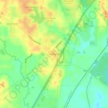
Name: New Byram topographic map, elevation, terrain.

Location: New Byram, Hinds County, Mississippi, 39272, United States (32.16543 -90.27953 32.20543 -90.23953)

Average elevation: 282 ft

Minimum elevation: 223 ft

Maximum elevation: 338 ft

Hinds County trails, hiking, mountain biking, running and outdoor activities

Other topographic maps

Click on a map to view its topography, its elevation and its terrain.

Jackson

United States > Mississippi > Hinds County

Average elevation: 315 ft

Raymond

United States > Mississippi > Hinds County

Average elevation: 289 ft

Edwards

United States > Mississippi > Hinds County

Average elevation: 223 ft

Clinton

United States > Mississippi > Hinds County

Average elevation: 308 ft

Clinton

United States > Mississippi > Hinds County

Average elevation: 308 ft

Jackson

United States > Mississippi > Hinds County

Average elevation: 315 ft

Jackson

United States > Mississippi > Hinds County

Average elevation: 315 ft

Gear up for your next adventure:

🪄Magnetic Compass - Accurate compass for navigation
🦺Reflective Outdoor Gear - Safety gear for low‑light conditions
😴Insulated Sleeping Pads - Compact and warm pads for high-elevation camping
🛶Inflatable Kayak - Portable kayak for rivers, lakes, and expeditions
📚Navigation Handbooks - Master the art of reading topographic maps and using a compass

As an Amazon Associate, this site earns from qualifying purchases at no extra cost to you.