Geolocate

Lysebotn topographic map

Interactive map

Click on the map to display elevation.

About this map

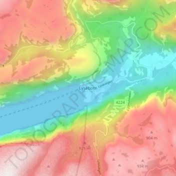
Name: Lysebotn topographic map, elevation, terrain.

Location: Lysebotn, Sandnes, Rogaland, 4127, Noruega (59.03514 6.62674 59.07514 6.66674)

Average elevation: 1,631 ft

Minimum elevation: -20 ft

Maximum elevation: 3,458 ft

Other topographic maps

Click on a map to view its topography, its elevation and its terrain.

Sauda

Noruega > Rogaland

Sauda, Rogaland, Noruega

Average elevation: 2,602 ft

Haugesund

Noruega > Rogaland

Haugesund, Rogaland, 5527, Noruega

Average elevation: 79 ft

Stavanger

Noruega > Rogaland

Stavanger, Rogaland, Noruega

Average elevation: 138 ft

Dirdal

Noruega > Rogaland

Dirdal, Gjesdal, Rogaland, Noruega

Average elevation: 827 ft

Grinde

Noruega > Rogaland

Grinde, Tysvær, Rogaland, 5570, Noruega

Average elevation: 217 ft

Stavanger

Noruega > Rogaland > Stavanger

Stavanger, Rogaland, 4006, Noruega

Average elevation: 144 ft

Madla

Noruega > Rogaland > Stavanger

Madla, Stavanger, Rogaland, Noruega

Average elevation: 75 ft