Geolocate

Mount Makiling topographic map

Click on the map to display elevation.

About this map

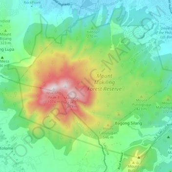
Name: Mount Makiling topographic map, elevation, terrain.

Location: Mount Makiling, Los Baños, Laguna, Calabarzon, Philippines (14.10412 121.16334 14.16788 121.24431)

Average elevation: 1,073 ft

Minimum elevation: 16 ft

Maximum elevation: 3,530 ft

Other topographic maps

Click on a map to view its topography, its elevation and its terrain.

Bagong Silang

Philippines > Laguna > Los Baños

Average elevation: 886 ft

Gear up for your next adventure:

🪶LED Camping Lantern - Bright lantern for camp lighting
🧦Hiking Socks - Comfortable socks to prevent blisters on long hikes
🎒Trekking Poles - Sturdy poles for balance and stability on rough terrain
🪶Paracord Bracelet - Survival bracelet with built‑in tools
🥾Women's Hiking Boots - Top-rated trail boots with ankle support and superior grip

As an Amazon Associate, this site earns from qualifying purchases at no extra cost to you.