
Make a donation
Gear up for your next adventure:
As an Amazon Associate, this site earns from qualifying purchases at no extra cost to you.
Lalakay topographic map
Click on the map to display elevation.
Make a donation
Gear up for your next adventure:
As an Amazon Associate, this site earns from qualifying purchases at no extra cost to you.
About this map
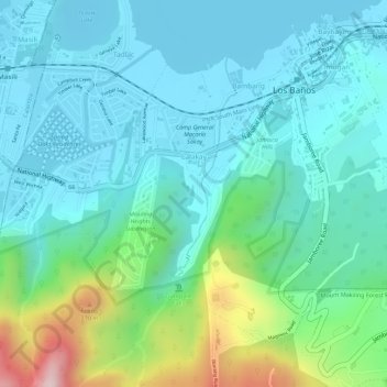
Name: Lalakay topographic map, elevation, terrain.
Location: Lalakay, Los Baños, Laguna, Calabarzon, 4030, Philippines (14.16360 121.20022 14.17706 121.21610)
Average elevation: 266 ft
Minimum elevation: 0 ft
Maximum elevation: 1,152 ft
Make a donation
Gear up for your next adventure:
As an Amazon Associate, this site earns from qualifying purchases at no extra cost to you.
Other topographic maps
Click on a map to view its topography, its elevation and its terrain.
Mount Makiling
Philippines > Laguna > Los Baños
Mount Makiling (also spelled Maquiling) is an inactive stratovolcano located in the provinces of Laguna and Batangas on the island of Luzon in the Philippines. The mountain rises to an elevation of 1,090 meters (3,580 ft) above mean sea level and is the highest feature of the Laguna Volcanic Field. The volcano…
Average elevation: 2,470 ft
Make a donation
Gear up for your next adventure:
As an Amazon Associate, this site earns from qualifying purchases at no extra cost to you.
Mount Makiling
Philippines > Laguna > Los Baños
Mount Makiling (also spelled Maquiling) is an inactive stratovolcano located in the provinces of Laguna and Batangas on the island of Luzon in the Philippines. The mountain rises to an elevation of 1,090 meters (3,580 ft) above mean sea level and is the highest feature of the Laguna Volcanic Field. The volcano…
Average elevation: 2,470 ft
Make a donation
Gear up for your next adventure:
As an Amazon Associate, this site earns from qualifying purchases at no extra cost to you.