Geolocate

Barnsley topographic map

Click on the map to display elevation.

About this map

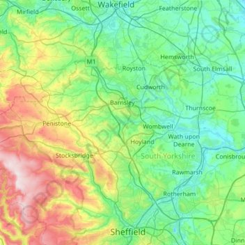
Name: Barnsley topographic map, elevation, terrain.

Location: Barnsley, South Yorkshire, England, United Kingdom (53.43830 -1.82259 53.61267 -1.27571)

Average elevation: 456 ft

Minimum elevation: 26 ft

Maximum elevation: 1,795 ft

Other topographic maps

Click on a map to view its topography, its elevation and its terrain.

London

United Kingdom > England > London

Average elevation: 138 ft

Brighton

United Kingdom > England > Brighton and Hove

Average elevation: 210 ft

Cambridge

United Kingdom > England > Cambridge

The city, like most of the UK, has a maritime climate highly influenced by the Gulf Stream. Located in the driest region of Britain, Cambridge's rainfall averages around 570 mm (22.44 in) per year, around half the national average, with some years occasionally falling into the semi-arid (under 500 mm (19.69…

Average elevation: 59 ft

York

United Kingdom > England > York

Average elevation: 69 ft

Batley

United Kingdom > England > Kirklees

Average elevation: 364 ft

Salisbury

United Kingdom > England > Salisbury

Bishop of Salisbury Hubert Walter was instrumental in the negotiations with Saladin during the Third Crusade, but he spent little time in his diocese prior to his elevation to archbishop of Canterbury. The brothers Herbert and Richard Poore succeeded him and began planning the relocation of the cathedral into…

Average elevation: 315 ft

Macclesfield

United Kingdom > England > Macclesfield

Average elevation: 620 ft

Norwich

United Kingdom > England > Norfolk > Norwich

Average elevation: 95 ft

Worksop

United Kingdom > England > Nottinghamshire > Bassetlaw

Average elevation: 184 ft

Carlisle

United Kingdom > England > Cumberland

Average elevation: 102 ft

Derby

United Kingdom > England > Derbyshire

Average elevation: 318 ft

Maker

United Kingdom > England > Cornwall > Kingsand

Average elevation: 98 ft

Zelah

United Kingdom > England > Cornwall

Average elevation: 279 ft

Marple Bridge

United Kingdom > England > Stockport

Average elevation: 482 ft

Castleford

United Kingdom > England > Wakefield

Average elevation: 108 ft

Enfield

United Kingdom > England > Greater London

Average elevation: 128 ft

Higher Badworthy

United Kingdom > England > Devon > South Hams > Didworthy

Average elevation: 820 ft

Fulham

United Kingdom > England

Average elevation: 56 ft

Hampstead Heath

United Kingdom > England > Greater London

Average elevation: 308 ft

Cheam

United Kingdom > England

Average elevation: 194 ft

Birkenhead

United Kingdom > England

Average elevation: 79 ft

Ruislip

United Kingdom > England

Average elevation: 177 ft

Portsmouth

United Kingdom > England > Hampshire > Portsmouth

By road, Portsmouth lies 73.5 miles (118.3 km) from Central London, 49.5 miles (79.7 km) west of Brighton, and 22.3 miles (35.9 km) east of Southampton. Portsmouth is situated primarily on Portsea Island and is the United Kingdom's only island city, although parts of it have expanded onto the mainland. Gosport…

Average elevation: 92 ft

Buckingham

United Kingdom > England > Buckingham

Average elevation: 328 ft

Brighton

United Kingdom > England > Brighton and Hove

Average elevation: 92 ft

Harby

United Kingdom > England > Leicestershire > Melton

Average elevation: 174 ft

Walthamstow

United Kingdom > England

Average elevation: 69 ft

Box Hill

United Kingdom > England > Surrey > Mole Valley > Pixham

The 15.8 km (9.8 mi) Box Hill Olympic circuit is generally cycled in an anticlockwise direction and begins to the south of the village of Mickleham with an ascent of the hill via the Zig Zag Road. From the National Trust Visitor Centre, the route turns eastwards, running along the escarpment and through the…

Average elevation: 344 ft

Caterham on the Hill

United Kingdom > England > Surrey

Average elevation: 564 ft

Epsom

United Kingdom > England > Surrey > Epsom and Ewell

Average elevation: 253 ft

Minehead

United Kingdom > England > Minehead

Average elevation: 223 ft

Melton Mowbray

United Kingdom > England > Leicestershire > Melton

Average elevation: 338 ft

Darwen

United Kingdom > England > Darwen

Much of the town was built between about 1850 and 1900; placenames, date stones in terraces, and the vernacular architecture of cellars, local stone, locally-made brick, pipework and tiles and leaded glass, the last now mostly gone, reflect this. It was one of the first places in the world to have steam trams.…

Average elevation: 791 ft

Ely

United Kingdom > England > Ely

For over 800 years the cathedral and its associated buildings—built on an elevation 68 feet (21 m) above the nearby fens—have visually influenced the city and its surrounding area. Geographer John Jones, writing in 1924, reports that "from the roof of King's Chapel in Cambridge, on a clear day, Ely can be…

Average elevation: 43 ft

Richmond

United Kingdom > England > London

The town centre lies just below 33 ft (10m) above sea level. South of the town centre, rising from Richmond Bridge to an elevation of 165 ft (50m), is Richmond Hill. Just beyond the summit of Richmond Hill is Richmond Park, an area of 2,360 acres (9.55 km2; 3.7 sq mi) of wild heath and woodland originally…

Average elevation: 56 ft

Leicester

United Kingdom > England > City of Leicester

Average elevation: 358 ft

Plymouth

United Kingdom > England > Devon > Plymouth

The River Plym, which flows off Dartmoor to the north-east, forms a smaller estuary to the east of the city called Cattewater. Plymouth Sound is protected from the sea by the Plymouth Breakwater, in use since 1814. In the Sound is Drake's Island which is seen from Plymouth Hoe, a flat public area on top of…

Average elevation: 266 ft

Leigh

United Kingdom > England

Average elevation: 112 ft

Box Hill Village

United Kingdom > England > Surrey > Mole Valley

Average elevation: 410 ft

Itchen Abbas

United Kingdom > England > Hampshire > Winchester

Average elevation: 266 ft

Newlands Corner

United Kingdom > England > Surrey > Guildford > Albury

Average elevation: 397 ft

Tottenham

United Kingdom > England

Tottenham's elevation is approximately 33 ft (10 m) above sea level.

Average elevation: 82 ft

Allestree Park

United Kingdom > England > Derby > Derby

Average elevation: 279 ft

Dorket Head

United Kingdom > England > Nottinghamshire > Gedling > Arnold

Average elevation: 371 ft

Woodborough Hill

United Kingdom > England > Wiltshire > Woodborough

Average elevation: 466 ft

Leeds

United Kingdom > England

Lying in the eastern foothills of the Pennines, there is a significant variation in elevation within the city's built-up area. The district ranges from 1,115 feet (340 m) in the far west on the slopes of Ilkley Moor to about 33 feet (10 m) where the rivers Aire and Wharfe cross the eastern boundary. Land rises…

Average elevation: 308 ft

Horsham

United Kingdom > England > West Sussex > Horsham > Horsham

Average elevation: 203 ft

Malvern

United Kingdom > England > Worcestershire > Malvern Hills

Malvern lies in the Lower Severn/Avon plain affording it a degree of shelter caused by virtue of its nestling in between the Cotswold hills to the east, the Welsh Hills and Mountains to the west, and Birmingham plateau to the north. Although as with all the British Isles it has a maritime climate, the local…

Average elevation: 312 ft

Lewisham

United Kingdom > England

Average elevation: 92 ft

Ashdown Forest

United Kingdom > England > East Sussex > Wealden

Ashdown Forest is an ancient area of open heathland occupying the highest sandy ridge-top of the High Weald Area of Outstanding Natural Beauty. It is situated 30 miles (48 km) south of London in the county East Sussex, England. Rising to an elevation of 732 feet (223 m) above sea level, its heights provide…

Average elevation: 384 ft

Streatham

United Kingdom > England

Average elevation: 121 ft

Abbess Roding

United Kingdom > England > Essex > Epping Forest

Average elevation: 240 ft

Ingleborough

United Kingdom > England > North Yorkshire > Ingleton

Average elevation: 1,637 ft

Isles of Scilly

United Kingdom > England

Average elevation: 7 ft

Walthamstow

United Kingdom > England > Greater London

Average elevation: 69 ft

Dronfield

United Kingdom > England > Dronfield

Average elevation: 522 ft

Clun

United Kingdom > England > Shropshire

Average elevation: 932 ft

Wallasey

United Kingdom > England

Wallasey is situated at the north-east of the Wirral Peninsula, on the western side of the River Mersey and adjoining the Irish Sea. The area is approximately 9.5 km (5.9 mi) east-north-east of the Dee Estuary at Hoylake. Wallasey is at an elevation of between 0–50 m (0–164 ft) above sea level, with the…

Average elevation: 39 ft

Okehampton

United Kingdom > England > Okehampton

Average elevation: 827 ft

Ashbourne

United Kingdom > England > Derbyshire Dales > Ashbourne

Average elevation: 564 ft

Garforth

United Kingdom > England > Leeds

Average elevation: 220 ft

Shaftesbury

United Kingdom > England > Shaftesbury

Average elevation: 443 ft

Marple

United Kingdom > England

Average elevation: 476 ft

Basingstoke

United Kingdom > England > Hampshire > Basingstoke and Deane

Situated in a valley through the Hampshire Downs at an average elevation of 88 metres (289 ft) Basingstoke is a major interchange between Reading, Newbury, Andover, Winchester, and Alton, and lies on the natural trade route between the southwest of England and London. The area had been something of an…

Average elevation: 358 ft

Chippenham

United Kingdom > England > Chippenham

Average elevation: 249 ft

Tiverton

United Kingdom > England > Mid Devon > Tiverton

Average elevation: 443 ft

Ashtead

United Kingdom > England > Surrey > Mole Valley

Average elevation: 246 ft

Horncastle

United Kingdom > England > East Lindsey > Horncastle

Average elevation: 171 ft

St Albans

United Kingdom > England > Hertfordshire > St Albans

St Albans was an ancient borough created following the dissolution of the monastery in 1539. It consisted of the ancient parish of St Albans (also known as the Abbey parish) and parts of St Michael and St Peter. The municipal corporation was reformed by the Municipal Corporations Act 1835 and the boundary was…

Average elevation: 328 ft

Peterborough

United Kingdom > England > Cambridgeshire

The local topography is flat, and in some places, the land lies below sea level, for example in parts of the Fens to the east and to the south of Peterborough. Human settlement in the area began before the Bronze Age, as can be seen at the Flag Fen archaeological site to the east of the current city centre,…

Average elevation: 56 ft

Dudley

United Kingdom > England > Dudley

Average elevation: 515 ft

Moreton

United Kingdom > England

Average elevation: 52 ft

Poole Bay

United Kingdom > England

Average elevation: 0 ft

Bideford Bay

United Kingdom > England

Average elevation: 0 ft

Mount's Bay

United Kingdom > England

Average elevation: 0 ft

Falmouth Bay

United Kingdom > England

Average elevation: 0 ft

Lyme Bay

United Kingdom > England

Average elevation: 0 ft

Liverpool Bay

United Kingdom > England

Average elevation: 0 ft

Gayton

United Kingdom > England

Average elevation: 135 ft

Keston

United Kingdom > England

Average elevation: 341 ft

Harefield

United Kingdom > England

Average elevation: 217 ft

Eastham Village

United Kingdom > England

Average elevation: 79 ft

Gear up for your next adventure:

🪵Folding Camp Saw - Compact saw for wood and campsite work
🥾Hiking Shoes - Durable and comfortable shoes for trail hiking
🛡️Bear Spray Outdoor - Protection in bear country hikes
🪶Multi‑Purpose Knife - Useful blade for camp and trail
🪶Camping Sleeping Pad - Comfortable sleeping pad for backpacking

As an Amazon Associate, this site earns from qualifying purchases at no extra cost to you.