
Peterborough topographic map
Click on the map to display elevation.
Peterborough
The local topography is flat, and in some places, the land lies below sea level, for example in parts of the Fens to the east and to the south of Peterborough. Human settlement in the area began before the Bronze Age, as can be seen at the Flag Fen archaeological site to the east of the current city centre, also with evidence of Roman occupation. The Anglo-Saxon period saw the establishment of a monastery, Medeshamstede, which later became Peterborough Cathedral.
About this map
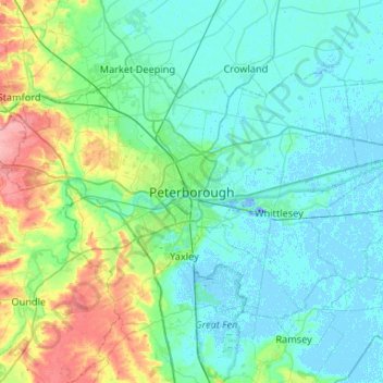
Name: Peterborough topographic map, elevation, terrain.
Average elevation: 56 ft
Minimum elevation: -62 ft
Maximum elevation: 302 ft
Other topographic maps
Click on a map to view its topography, its elevation and its terrain.
Cambridge
United Kingdom > England > Cambridgeshire
The city, like most of the UK, has a maritime climate highly influenced by the Gulf Stream. Located in the driest region of Britain, Cambridge's rainfall averages around 570 mm (22.44 in) per year, around half the national average, The driest recent year was in 2011 with 380.4 mm (14.98 in) of rain at the…
Average elevation: 59 ft
Ely
United Kingdom > England > Cambridgeshire
Ely is built on a 23-square-mile (60 km2) Kimmeridge Clay island which, at 85 feet (26 m), is the highest land in the Fens. It was due to this topography that Ely was not waterlogged like the surrounding Fenland, and was an island separated from the mainland. Major rivers including the Witham, Welland, Nene…
Average elevation: 13 ft
Great Staughton
United Kingdom > England > Cambridgeshire > Huntingdonshire > Great Staughton
Average elevation: 141 ft
River Great Ouse or Ely Ouse
United Kingdom > England > Cambridgeshire > East Cambridgeshire > Soham > Stuntney
Average elevation: 13 ft
Brampton
United Kingdom > England > Cambridgeshire > Huntingdonshire > Brampton
Average elevation: 72 ft
Barway
United Kingdom > England > Cambridgeshire > East Cambridgeshire > Soham
Average elevation: 7 ft
West Wratting
United Kingdom > England > Cambridgeshire > South Cambridgeshire
Average elevation: 302 ft
Westley Waterless
United Kingdom > England > Cambridgeshire > East Cambridgeshire
Average elevation: 302 ft
Hinchingbrooke Country Park
United Kingdom > England > Cambridgeshire > Huntingdonshire > Huntingdon > Brampton
Average elevation: 52 ft
Kimbolton
United Kingdom > England > Cambridgeshire > Huntingdonshire > Kimbolton
Average elevation: 177 ft
Great Abington
United Kingdom > England > Cambridgeshire > South Cambridgeshire
Average elevation: 180 ft
Great Shelford
United Kingdom > England > Cambridgeshire > South Cambridgeshire
Average elevation: 72 ft
Bluntisham
United Kingdom > England > Cambridgeshire > Huntingdonshire > Bluntisham
Average elevation: 39 ft
Stretham
United Kingdom > England > Cambridgeshire > East Cambridgeshire > Stretham
Average elevation: 13 ft
Grafham
United Kingdom > England > Cambridgeshire > Huntingdonshire > Grafham
Average elevation: 148 ft
West Wickham
United Kingdom > England > Cambridgeshire > South Cambridgeshire
Average elevation: 338 ft
Kings Ripton
United Kingdom > England > Cambridgeshire > Huntingdonshire > Kings Ripton
Average elevation: 112 ft
Little Thetford
United Kingdom > England > Cambridgeshire > East Cambridgeshire
Average elevation: 16 ft