
Make a donation
Gear up for your next adventure:
As an Amazon Associate, this site earns from qualifying purchases at no extra cost to you.
Algaida topographic map
Click on the map to display elevation.
Make a donation
Gear up for your next adventure:
As an Amazon Associate, this site earns from qualifying purchases at no extra cost to you.
About this map
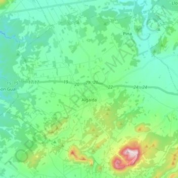
Name: Algaida topographic map, elevation, terrain.
Location: Algaida, Pla de Mallorca, Islas Baleares, España (39.51634 2.82836 39.61403 2.96893)
Average elevation: 587 ft
Minimum elevation: 249 ft
Maximum elevation: 1,788 ft
Make a donation
Gear up for your next adventure:
As an Amazon Associate, this site earns from qualifying purchases at no extra cost to you.
Other topographic maps
Click on a map to view its topography, its elevation and its terrain.
Make a donation
Gear up for your next adventure:
As an Amazon Associate, this site earns from qualifying purchases at no extra cost to you.
Petra
España > Islas Baleares > Pla de Mallorca > Petra > Petra
Petra se encuentra a mitad de camino entre el golfo de Aqaba y el mar Muerto a una altitud de 800 a 1396 m s. n. m. (metros sobre el nivel del mar) en un valle de la región montañosa de Edom, al este del valle del Arabah. Hoy, Petra está alrededor de 200 km (kilómetros) al suroeste de la capital jordana…
Average elevation: 351 ft
Make a donation
Gear up for your next adventure:
As an Amazon Associate, this site earns from qualifying purchases at no extra cost to you.