
Colebrook topographic map
Click on the map to display elevation.
Colebrook
According to the United States Census Bureau, the town of Colebrook has a total area of 40.7 square miles (105.5 km2), of which 40.5 square miles (104.9 km2) are land and 0.2 square miles (0.5 km2) are water, comprising 0.51% of the town. The highest point in Colebrook is Van Dyck Mountain, elevation 2,760 feet (840 m), in the northeast corner of the town. Colebrook's western view is dominated by Monadnock Mountain, elevation 3,148 ft (960 m), in Lemington, Vermont. Colebrook is drained by the Mohawk River, which flows into the Connecticut River. Beaver Brook joins the Mohawk from the north in Colebrook village. The town lies almost fully within the Connecticut River watershed, with a tiny portion of the northeast corner of town lying in the Androscoggin River watershed.
About this map
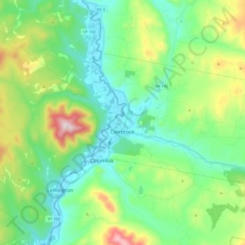
Name: Colebrook topographic map, elevation, terrain.
Location: Colebrook, Coös County, New Hampshire, 03576, United States (44.85632 -71.52306 44.94316 -71.30820)
Average elevation: 1,562 ft
Minimum elevation: 984 ft
Maximum elevation: 3,127 ft
Coos County trails, hiking, mountain biking, running and outdoor activities
Other topographic maps
Click on a map to view its topography, its elevation and its terrain.
Jefferson Highland
United States > New Hampshire > Coos County > Jefferson > Jefferson Highland
Average elevation: 1,480 ft
LIttle Diamond Pond
United States > New Hampshire > Coos County > Stewartstown
Average elevation: 2,274 ft
Wildcat Mountain
United States > New Hampshire > Coos County
Wildcat Mountain has five summits — A, B, C, D, and E — along Wildcat Ridge, which curves two miles (3 km) to the south and west. Both A, at 4,422 feet (1,348 m), and D, at 4,062 feet (1,238 m), are considered "four-thousand footers". B, with an elevation of 4,305 feet (1,312 m), and C, at 4,285 feet…
Average elevation: 3,461 ft
Pinkham Notch
United States > New Hampshire > Coos County
Pinkham Notch (elevation 2032 ft. / 619 m) is a mountain pass in the White Mountains of north-central New Hampshire, United States. The notch is a result of extensive erosion by the Laurentide Ice Sheet during the Wisconsinian ice age. Pinkham Notch was eroded into a glacial U-shaped valley whose walls are…
Average elevation: 2,516 ft