
Castellated Ridge topographic map
Click on the map to display elevation.
About this map
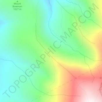
Name: Castellated Ridge topographic map, elevation, terrain.
Average elevation: 3,543 ft
Minimum elevation: 2,444 ft
Maximum elevation: 5,604 ft
Coos County trails, hiking, mountain biking, running and outdoor activities
Other topographic maps
Click on a map to view its topography, its elevation and its terrain.
Colebrook
United States > New Hampshire > Coos County
According to the United States Census Bureau, the town of Colebrook has a total area of 40.7 square miles (105.5 km2), of which 40.5 square miles (104.9 km2) are land and 0.2 square miles (0.5 km2) are water, comprising 0.51% of the town. The highest point in Colebrook is Van Dyck Mountain, elevation 2,760…
Average elevation: 1,562 ft
Lancaster
United States > New Hampshire > Coos County
Just south of the village center is Mount Prospect, summer home to Senator John W. Weeks, who sponsored congressional legislation creating White Mountain National Forest. In 1910, he purchased several farms to assemble the 420-acre (170 ha) estate. It is now Weeks State Park, which features a fire lookout and…
Average elevation: 1,217 ft
Jefferson Highland
United States > New Hampshire > Coos County > Jefferson > Jefferson Highland
Average elevation: 1,480 ft
Wildcat Mountain
United States > New Hampshire > Coos County
Wildcat Mountain has five summits — A, B, C, D, and E — along Wildcat Ridge, which curves two miles (3 km) to the south and west. Both A, at 4,422 feet (1,348 m), and D, at 4,062 feet (1,238 m), are considered "four-thousand footers". B, with an elevation of 4,305 feet (1,312 m), and C, at 4,285 feet…
Average elevation: 3,461 ft
Pinkham Notch
United States > New Hampshire > Coos County
Pinkham Notch (elevation 2032 ft. / 619 m) is a mountain pass in the White Mountains of north-central New Hampshire, United States. The notch is a result of extensive erosion by the Laurentide Ice Sheet during the Wisconsinian ice age. Pinkham Notch was eroded into a glacial U-shaped valley whose walls are…
Average elevation: 2,516 ft