Geolocate

West Liberty topographic map

Click on the map to display elevation.

About this map

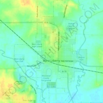
Name: West Liberty topographic map, elevation, terrain.

Location: West Liberty, Muscatine County, Iowa, 52776, United States (41.55598 -91.28036 41.58997 -91.24814)

Average elevation: 676 ft

Minimum elevation: 640 ft

Maximum elevation: 738 ft

Muscatine County trails, hiking, mountain biking, running and outdoor activities

Other topographic maps

Click on a map to view its topography, its elevation and its terrain.

Montpelier

United States > Iowa > Muscatine County

Average elevation: 614 ft

Dayfield

United States > Iowa > Muscatine County

Average elevation: 696 ft

Gear up for your next adventure:

🧼Biodegradable Camping Soap - Eco‑friendly soap for outdoor hygiene
🔦Powerful Headlamps - Ultra-bright hands-free lighting for night navigation
🚗GPS Dash Cams - Record your scenic drives through mountain passes and canyons
🏥Hiking First Aid Kits - Comprehensive medical kits for remote trail injuries
👓Polarized Sunglasses - Outdoor sunglasses for glare reduction

As an Amazon Associate, this site earns from qualifying purchases at no extra cost to you.