
Make a donation
Gear up for your next adventure:
As an Amazon Associate, this site earns from qualifying purchases at no extra cost to you.
Montpelier topographic map
Click on the map to display elevation.
Make a donation
Gear up for your next adventure:
As an Amazon Associate, this site earns from qualifying purchases at no extra cost to you.
About this map
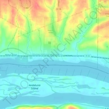
Name: Montpelier topographic map, elevation, terrain.
Location: Montpelier, Muscatine County, Iowa, 52759, United States (41.43920 -90.82709 41.47920 -90.78709)
Average elevation: 614 ft
Minimum elevation: 541 ft
Maximum elevation: 771 ft
Muscatine County trails, hiking, mountain biking, running and outdoor activities
Make a donation
Gear up for your next adventure:
As an Amazon Associate, this site earns from qualifying purchases at no extra cost to you.
Other topographic maps
Click on a map to view its topography, its elevation and its terrain.
Wilton
United States > Iowa > Muscatine County
According to the United States Census Bureau, the city has a total area of 1.95 square miles (5.05 km2), all land. The city sits at an elevation of 679 feet.
Average elevation: 689 ft