
Make a donation
Gear up for your next adventure:
As an Amazon Associate, this site earns from qualifying purchases at no extra cost to you.
Hintereck topographic map
Click on the map to display elevation.
Make a donation
Gear up for your next adventure:
As an Amazon Associate, this site earns from qualifying purchases at no extra cost to you.
About this map
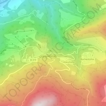
Name: Hintereck topographic map, elevation, terrain.
Average elevation: 3,114 ft
Minimum elevation: 1,703 ft
Maximum elevation: 4,656 ft
Make a donation
Gear up for your next adventure:
As an Amazon Associate, this site earns from qualifying purchases at no extra cost to you.
Other topographic maps
Click on a map to view its topography, its elevation and its terrain.
Unterau
Deutschland > Bayern > Landkreis Berchtesgadener Land > Berchtesgaden
Average elevation: 2,461 ft
Mitterbach
Deutschland > Bayern > Landkreis Berchtesgadener Land > Berchtesgaden
Average elevation: 2,310 ft
Obersalzberg
Deutschland > Bayern > Landkreis Berchtesgadener Land > Berchtesgaden > Untersalzberg I
Die Gemeindeteile Obersalzberg, Untersalzberg I und Untersalzberg II (hier ist u. a. auch die Einfahrt in das Salzbergwerk) verteilen sich über den Salzberg bis zu dessen Ausläufern an der Berchtesgadener Ache. Der Salzberg selbst ist ein „Bergrücken“ mit einer Höhe von etwa 1000 m, der dem südlich…
Average elevation: 3,061 ft
Untersalzberg I
Deutschland > Bayern > Landkreis Berchtesgadener Land > Berchtesgaden > Untersalzberg I
Average elevation: 2,487 ft
Make a donation
Gear up for your next adventure:
As an Amazon Associate, this site earns from qualifying purchases at no extra cost to you.
Saurüssel
Deutschland > Bayern > Landkreis Berchtesgadener Land > Berchtesgaden
Average elevation: 2,431 ft
Buchenhöhe
Deutschland > Bayern > Landkreis Berchtesgadener Land > Berchtesgaden
Average elevation: 3,606 ft
Klaushöhe
Deutschland > Bayern > Landkreis Berchtesgadener Land > Berchtesgaden
Average elevation: 3,504 ft
Auerdörfl
Deutschland > Bayern > Landkreis Berchtesgadener Land > Berchtesgaden > Oberau
Average elevation: 2,680 ft
Make a donation
Gear up for your next adventure:
As an Amazon Associate, this site earns from qualifying purchases at no extra cost to you.
Spornhof
Deutschland > Bayern > Landkreis Berchtesgadener Land > Berchtesgaden > Unterau
Average elevation: 2,671 ft
Kehlstein
Deutschland > Bayern > Landkreis Berchtesgadener Land > Berchtesgaden
Average elevation: 4,649 ft
Koppenleiten
Deutschland > Bayern > Landkreis Berchtesgadener Land > Berchtesgaden > Unterau
Average elevation: 2,461 ft
Kranzbichl
Deutschland > Bayern > Landkreis Berchtesgadener Land > Berchtesgaden > Untersalzberg II
Average elevation: 2,408 ft
Make a donation
Gear up for your next adventure:
As an Amazon Associate, this site earns from qualifying purchases at no extra cost to you.
Untersalzberg II
Deutschland > Bayern > Landkreis Berchtesgadener Land > Berchtesgaden
Average elevation: 2,418 ft
Unterau
Deutschland > Bayern > Landkreis Berchtesgadener Land > Berchtesgaden
Average elevation: 2,461 ft