
Thank you for supporting this site ❤️
Make a donation
Make a donation
Gear up for your next adventure:
As an Amazon Associate, this site earns from qualifying purchases at no extra cost to you.
Amizour topographic map
Click on the map to display elevation.
Thank you for supporting this site ❤️
Make a donation
Make a donation
Gear up for your next adventure:
As an Amazon Associate, this site earns from qualifying purchases at no extra cost to you.
About this map
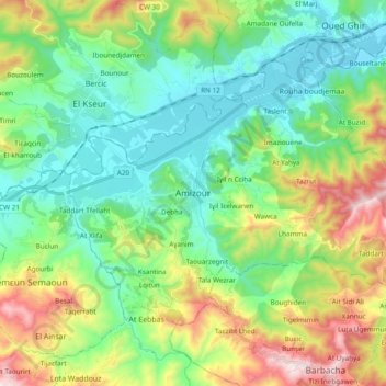
Name: Amizour topographic map, elevation, terrain.
Location: Amizour, Amizour District, Bejaia, 06300, Algeria (36.59174 4.84086 36.69699 5.03338)
Average elevation: 846 ft
Minimum elevation: 26 ft
Maximum elevation: 2,743 ft
Thank you for supporting this site ❤️
Make a donation
Make a donation
Gear up for your next adventure:
As an Amazon Associate, this site earns from qualifying purchases at no extra cost to you.