
Make a donation
Gear up for your next adventure:
As an Amazon Associate, this site earns from qualifying purchases at no extra cost to you.
Moosic topographic map
Click on the map to display elevation.
Make a donation
Gear up for your next adventure:
As an Amazon Associate, this site earns from qualifying purchases at no extra cost to you.
Moosic
Moosic is located in the Wyoming Valley of northeastern Pennsylvania. In terms of physiography, Moosic is part of the Ridge and Valley province of the Appalachian Mountains. Moosic is located at an elevation of 817 feet (249 m) above sea level. The major body of water flowing through the borough is the Lackawanna River, part of the Upper Susquehanna-Lackawanna Watershed. Moosic has a total area of 6.6 square miles (17 km2), of which 6.5 square miles (17 km2) is land and 0.1 square miles (0.26 km2) (1.52%) is water. Moosic has a humid continental climate (Köppen Dfa) with four distinct seasons. Summers are humid and warm, with an occasional heatwave. Winters are cold and snowy.
Make a donation
Gear up for your next adventure:
As an Amazon Associate, this site earns from qualifying purchases at no extra cost to you.
About this map
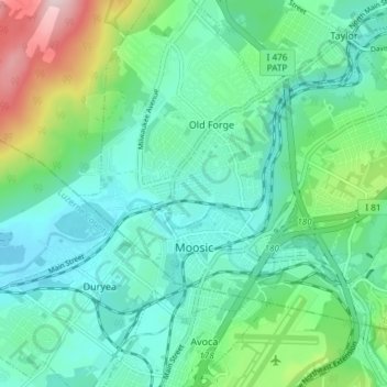
Name: Moosic topographic map, elevation, terrain.
Average elevation: 807 ft
Minimum elevation: 545 ft
Maximum elevation: 1,657 ft
Lackawanna County trails, hiking, mountain biking, running and outdoor activities
Make a donation
Gear up for your next adventure:
As an Amazon Associate, this site earns from qualifying purchases at no extra cost to you.
Other topographic maps
Click on a map to view its topography, its elevation and its terrain.
Mount Cobb
United States > Pennsylvania > Lackawanna County > Jefferson Township
Average elevation: 1,736 ft
Wimmers
United States > Pennsylvania > Lackawanna County > Jefferson Township > Mount Cobb
Average elevation: 1,624 ft
Make a donation
Gear up for your next adventure:
As an Amazon Associate, this site earns from qualifying purchases at no extra cost to you.
Pine Hill Vista
United States > Pennsylvania > Lackawanna County > Thornhurst Township
Average elevation: 2,060 ft
Make a donation
Gear up for your next adventure:
As an Amazon Associate, this site earns from qualifying purchases at no extra cost to you.
Birchwood Estates
United States > Pennsylvania > Lackawanna County > Roaring Brook Township
Average elevation: 1,680 ft
Falling Springs Reservoir
United States > Pennsylvania > Lackawanna County > Ransom Township
Average elevation: 1,230 ft
Madisonville
United States > Pennsylvania > Lackawanna County > Madison Township
Average elevation: 1,680 ft
Make a donation
Gear up for your next adventure:
As an Amazon Associate, this site earns from qualifying purchases at no extra cost to you.
Mount Cobb
United States > Pennsylvania > Lackawanna County > Jefferson Township
Average elevation: 1,736 ft
Make a donation
Gear up for your next adventure:
As an Amazon Associate, this site earns from qualifying purchases at no extra cost to you.
Elmhurst
United States > Pennsylvania > Lackawanna County > Elmhurst Township
Average elevation: 1,568 ft
Spring Brook
United States > Pennsylvania > Lackawanna County > Spring Brook Township
Average elevation: 1,519 ft
Montage Mountain
United States > Pennsylvania > Lackawanna County > Scranton
Average elevation: 1,585 ft
Make a donation
Gear up for your next adventure:
As an Amazon Associate, this site earns from qualifying purchases at no extra cost to you.
Waverly
United States > Pennsylvania > Lackawanna County > Waverly Township
Average elevation: 1,230 ft
Eagle Lake
United States > Pennsylvania > Lackawanna County > Covington Township
Average elevation: 1,896 ft
Make a donation
Gear up for your next adventure:
As an Amazon Associate, this site earns from qualifying purchases at no extra cost to you.