
Make a donation
Gear up for your next adventure:
As an Amazon Associate, this site earns from qualifying purchases at no extra cost to you.
Apolo topographic map
Click on the map to display elevation.
Make a donation
Gear up for your next adventure:
As an Amazon Associate, this site earns from qualifying purchases at no extra cost to you.
Apolo
Apolo es una pequeña ciudad del municipio homónimo y capital de la provincia de Franz Tamayo (antes Caupolicán), ubicada esta en el centro norte del departamento de La Paz (Bolivia). Según el último censo oficial realizado por el Instituto Nacional de Estadística de Bolivia (INE) en 2012, el municipio cuenta con una población de 20.308 habitantes y está situado a una altitud promedio de 1.400 metros sobre el nivel del mar.
Make a donation
Gear up for your next adventure:
As an Amazon Associate, this site earns from qualifying purchases at no extra cost to you.
About this map
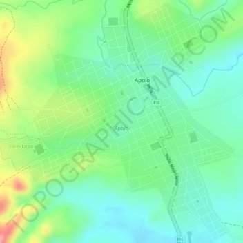
Name: Apolo topographic map, elevation, terrain.
Average elevation: 4,787 ft
Minimum elevation: 4,646 ft
Maximum elevation: 5,043 ft
Make a donation
Gear up for your next adventure:
As an Amazon Associate, this site earns from qualifying purchases at no extra cost to you.
Other topographic maps
Click on a map to view its topography, its elevation and its terrain.
Antaquilla
Bolivia > La Paz > Provincia Franz Tamayo > Municipio Pelechuco
Average elevation: 15,079 ft
San Antonio
Bolivia > La Paz > Provincia Franz Tamayo > Municipio Pelechuco
Average elevation: 5,564 ft
San Pedro
Bolivia > La Paz > Provincia Franz Tamayo > Municipio Apolo > San Pedro
Average elevation: 4,455 ft
Make a donation
Gear up for your next adventure:
As an Amazon Associate, this site earns from qualifying purchases at no extra cost to you.
Pelechuco
Bolivia > La Paz > Provincia Franz Tamayo > Municipio Pelechuco
Average elevation: 13,041 ft
Hichocollo Alto
Bolivia > La Paz > Provincia Franz Tamayo > Municipio Pelechuco > Hichocollo
Average elevation: 14,478 ft
Copacabana
Bolivia > La Paz > Provincia Franz Tamayo > Municipio Apolo > Copacabana
Average elevation: 4,377 ft
Make a donation
Gear up for your next adventure:
As an Amazon Associate, this site earns from qualifying purchases at no extra cost to you.