
Make a donation
Gear up for your next adventure:
As an Amazon Associate, this site earns from qualifying purchases at no extra cost to you.
Bridgewater topographic map
Click on the map to display elevation.
Make a donation
Gear up for your next adventure:
As an Amazon Associate, this site earns from qualifying purchases at no extra cost to you.
About this map
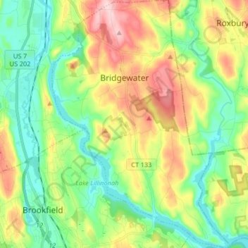
Name: Bridgewater topographic map, elevation, terrain.
Average elevation: 456 ft
Minimum elevation: 174 ft
Maximum elevation: 948 ft
Western Connecticut Planning Region trails, hiking, mountain biking, running and outdoor activities
Make a donation
Gear up for your next adventure:
As an Amazon Associate, this site earns from qualifying purchases at no extra cost to you.
Other topographic maps
Click on a map to view its topography, its elevation and its terrain.
Silvermine
United States > Connecticut > Western Connecticut Planning Region > Norwalk
Average elevation: 213 ft
Shippan Point
United States > Connecticut > Western Connecticut Planning Region > Stamford
Average elevation: 10 ft
Brookfield Center
United States > Connecticut > Western Connecticut Planning Region > Brookfield
Average elevation: 436 ft
North Wilton
United States > Connecticut > Western Connecticut Planning Region > Wilton
Average elevation: 453 ft
Make a donation
Gear up for your next adventure:
As an Amazon Associate, this site earns from qualifying purchases at no extra cost to you.
Cedarhurst
United States > Connecticut > Western Connecticut Planning Region > Newtown
Average elevation: 364 ft
Pine Hill
United States > Connecticut > Western Connecticut Planning Region > Greenwich
Average elevation: 289 ft
Mill River Park
United States > Connecticut > Western Connecticut Planning Region > Stamford
Average elevation: 59 ft
Winnipauk Village
United States > Connecticut > Western Connecticut Planning Region > Norwalk
Average elevation: 112 ft
Make a donation
Gear up for your next adventure:
As an Amazon Associate, this site earns from qualifying purchases at no extra cost to you.
Sellecks Corners
United States > Connecticut > Western Connecticut Planning Region > New Canaan
Average elevation: 449 ft
Pemberwick
United States > Connecticut > Western Connecticut Planning Region > Greenwich
Average elevation: 148 ft
Botsford
United States > Connecticut > Western Connecticut Planning Region > Newtown
Average elevation: 459 ft
Glenville
United States > Connecticut > Western Connecticut Planning Region > Greenwich
Average elevation: 177 ft
Make a donation
Gear up for your next adventure:
As an Amazon Associate, this site earns from qualifying purchases at no extra cost to you.
Putnam Memorial State Park
United States > Connecticut > Western Connecticut Planning Region > Redding
Average elevation: 705 ft
Norwalk River
United States > Connecticut > Western Connecticut Planning Region > Wilton > Cannondale
Average elevation: 348 ft
Darien Pond
United States > Connecticut > Western Connecticut Planning Region > New Canaan
Average elevation: 233 ft
Ponus
United States > Connecticut > Western Connecticut Planning Region > New Canaan
Average elevation: 253 ft
Make a donation
Gear up for your next adventure:
As an Amazon Associate, this site earns from qualifying purchases at no extra cost to you.
North Stamford
United States > Connecticut > Western Connecticut Planning Region > Stamford
Average elevation: 292 ft
Ball Pond
United States > Connecticut > Western Connecticut Planning Region > New Fairfield
Average elevation: 728 ft
Bigelow Corners
United States > Connecticut > Western Connecticut Planning Region > New Fairfield
Average elevation: 728 ft
Bogus Hill
United States > Connecticut > Western Connecticut Planning Region > New Fairfield
Average elevation: 528 ft
Make a donation
Gear up for your next adventure:
As an Amazon Associate, this site earns from qualifying purchases at no extra cost to you.
Candlewood Isle
United States > Connecticut > Western Connecticut Planning Region > New Fairfield
Average elevation: 577 ft
Candlewood Knolls
United States > Connecticut > Western Connecticut Planning Region > New Fairfield
Average elevation: 577 ft
Candlewood Orchards
United States > Connecticut > Western Connecticut Planning Region > Brookfield
Average elevation: 463 ft
Candlewood Shores
United States > Connecticut > Western Connecticut Planning Region > Brookfield
Average elevation: 472 ft
Make a donation
Gear up for your next adventure:
As an Amazon Associate, this site earns from qualifying purchases at no extra cost to you.
Cos Cob
United States > Connecticut > Western Connecticut Planning Region > Greenwich
Average elevation: 56 ft
Dodgingtown
United States > Connecticut > Western Connecticut Planning Region > Newtown
Average elevation: 591 ft
Hawleyville
United States > Connecticut > Western Connecticut Planning Region > Newtown
Average elevation: 476 ft
Knollcrest
United States > Connecticut > Western Connecticut Planning Region > New Fairfield
Average elevation: 607 ft
Make a donation
Gear up for your next adventure:
As an Amazon Associate, this site earns from qualifying purchases at no extra cost to you.
Mamanasco Lake Dam
United States > Connecticut > Western Connecticut Planning Region > Ridgefield
Average elevation: 689 ft
Mill Plain
United States > Connecticut > Western Connecticut Planning Region > Danbury
Average elevation: 623 ft
Ridgebury
United States > Connecticut > Western Connecticut Planning Region > Ridgefield
Average elevation: 640 ft
Rock Ridge
United States > Connecticut > Western Connecticut Planning Region > Greenwich
Average elevation: 148 ft
Make a donation
Gear up for your next adventure:
As an Amazon Associate, this site earns from qualifying purchases at no extra cost to you.
South Wilton
United States > Connecticut > Western Connecticut Planning Region > Wilton
Average elevation: 230 ft
Tokeneke
United States > Connecticut > Western Connecticut Planning Region > Darien
Average elevation: 46 ft
Topstone
United States > Connecticut > Western Connecticut Planning Region > Redding
Average elevation: 561 ft
West Mountain
United States > Connecticut > Western Connecticut Planning Region > Ridgefield
Average elevation: 794 ft
Make a donation
Gear up for your next adventure:
As an Amazon Associate, this site earns from qualifying purchases at no extra cost to you.
Hattertown
United States > Connecticut > Western Connecticut Planning Region > Newtown
Average elevation: 597 ft
Richards Corner
United States > Connecticut > Western Connecticut Planning Region > New Canaan
Average elevation: 400 ft
Riverbank
United States > Connecticut > Western Connecticut Planning Region > Stamford
Average elevation: 236 ft
Roxbury
United States > Connecticut > Western Connecticut Planning Region > Stamford
Average elevation: 157 ft
Make a donation
Gear up for your next adventure:
As an Amazon Associate, this site earns from qualifying purchases at no extra cost to you.
Noroton
United States > Connecticut > Western Connecticut Planning Region > Darien
Average elevation: 59 ft