Geolocate
👉 Easily get elevation data in JSON, GeoTIFF and KML formats using Elevation API
Thank you for supporting this site ❤️
Make a donation

Weyburn topographic map

Click on the map to display elevation.

About this map

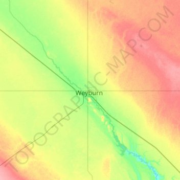
Name: Weyburn topographic map, elevation, terrain.

Location: Weyburn, Saskatchewan, S4H 2J4, Canada (49.50941 -104.01101 49.82941 -103.69101)

Average elevation: 1,919 ft

Minimum elevation: 1,814 ft

Maximum elevation: 2,051 ft

Gear up for your next adventure:

😴Insulated Sleeping Pads - Compact and warm pads for high-elevation camping
👖Convertible Hiking Pants - Versatile zip-off pants for changing altitudes and temperatures
📱Heavy-Duty Phone Cases - Drop-proof and waterproof protection for outdoor navigation
🔥Plasma Lighters - Windproof lighters that work in any weather condition
📡GPS Antenna Upgrade - Enhance GPS reception in remote terrain

As an Amazon Associate, this site earns from qualifying purchases at no extra cost to you.